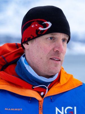
Christian Jaedicke is Adjunct Professor (20%) at the Department of Geosciences. His main position is at the Norwegian Geotechnical Institute – NGI.
Academic interests
- Snow physics
- Avalanches
- Weather and natural hazards
- Risk management
Courses taught
• GEO4171 – Floods, Avalanches and Landslides
Background
Master in hydrology from Uppsala University, Ph.D. from UNIS / UiB in meteorology and snow physics, 20 years experiences as researcher and avalanche expert at the Norwegian Geotechnical Institute. Guest lecturer at the UNIS - The university centre in Svalbard and the UiT The Arctic University of Norway.
Publications
-
Hancock, Holt John; Gisnås, Kjersti Gleditsch; Gauer, Peter; Aksamit, Nikolas Olson; Poltronieri, Anna & Jaedicke, Christian
[Show all 7 contributors for this article]
(2026).
A Practitioner's Perspective on Tools for Understanding Wind Fields, Snow Drift, and Snow Distribution,
Proceedings of the International Snow Science Workshop.
doi:
10.15788/1790098596.
Full text in Research Archive
Show summary
Understanding how, where, and when snow accumulates due to blowing and drifting snow processes plays a key role in avalanche forecasting, hazard mapping, and design of structural mitigation measures. Despite the recognized importance of wind redistribution in controlling avalanche activity and the availability of multiple tools to simulate wind and snow conditions in mountain environments, avalanche workers still experience challenges incorporating snow drift processes into operational workflows. In this work, we use spatially-distributed snow height measurements obtained from terrestrial laser scanning (TLS) at two sites in Norway during the 2024/2025 winter season to validate and compare a range of approaches for parameterizing snow drift and predicting snow distribution. We simulate or recreate the observed snow distribution patterns using methods spanning a continuum of model complexity from semi-empirical, terrain-based parameterizations, to open-source wind field models, to physically-based numerical models representing snow particle trajectories. We evaluate model outputs against TLS-derived snow height changes to assess each approach's ability to capture key features of snow deposition and erosion in the context of practical avalanche work. Our results highlight the strengths and limitations of different modeling approaches and provide insight into how model complexity, spatial resolution of forcing data, and computational efforts influence model output utility. These findings will help to support practitioner decision-making when selecting tools appropriate for specific forecasting, planning, or engineering applications.
-
Jaedicke, Christian; Kveldsvik, Vidar; Kleiven, Anders; Skuset, Sunniva; Hancock, Holt John & Morken, Elise
[Show all 10 contributors for this article]
(2025).
Risk management from natural hazards for the new European Road E10, Hålogalandsveien.
In Sigtryggsdóttir, Fjóla Guðrún; Gauer, Peter; Þorvaldsdóttir, Sólveig; Margreth, Stefan & Margreth, Stefan (Ed.),
Snow 2025. International Symposium on Mitigation Measures against Snow Avalanches and other Rapid Gravity Mass Flows.
p. 143–149.
doi:
https:/www.vfi.is/media/utgafa/SNOW2025_Iceland_Proceedings.pdf.
Full text in Research Archive
Show summary
The 82 km section of the European Road E10 from Tjelsund Bridge to the Sigerfjord tunnel is currently under reconstruction. Seven tunnels with a total combined length of 27 km will be drilled to make the road shorter and to avoid exposure to avalanche terrain. Outside of the tunnels, other road sections will require protection from structural mitigation measures to limit the risk from rockfalls, avalanches and slushflows. A variety of mitigation measures will ultimately protect the exposed stretches of road against slope hazards. For rockfalls, local rock anchors and nettings will secure smaller outcrops, while catching nets will provide protection from larger release areas. Bridges with sufficient clearance will elevate the road over known slushflow channels and will be supplemented by catching basins, which retain the slush before it enters the road. Several types of dams such as retention and guiding dams are used to mitigate avalanches. Where the new roadway parallels the shoreline of Gullesfjord, dams with sufficient dimensions to protect the road proved to be too expensive to realistically complete. Therefore, a combination of smaller dams and remote avalanche control systems is suggested for the area. During construction of the roadway and the protection structures, workers and construction sites are exposed to avalanche hazard. A site-specific avalanche warning service was established to manage the avalanche hazard. In daily forecasts, the avalanche impact probability is assessed individually for each exposed work site. Predefined working routines corresponding to the forecast impact probability were implemented. This allowed the daily work plan to be adapted to the avalanche risk and ensured safe execution of the construction work during winter.
-
Gauer, Peter; Helgaas, Ole-Andre; Gisnås, Kjersti Gleditsch; Jaedicke, Christian & Humstad, Tore
(2024).
A brief history on avalanche mitigation in Northern Norway.
In Gauer, Peter; Dahle, Halgeir; Eckerstorfer, Markus; Mannberg, Andrea & Müller, Karsten (Ed.),
Proceedings of the international Snow Science Workshop ISSW 2024 “A merging of theory and practice”.
p. 799–807.
doi:
https:/arc.lib.montana.edu/snow-science/item.php?id=3229.
Full text in Research Archive
Show summary
Winter conditions in Northern-Norway are challenging due to the extreme arctic climate and midwinter-darkness. Polar proximity and the warm branch of the Gulf Stream through the Norwegian sea contribute to variable winter conditions with long cold-periods and intermittent warm-spells. Polar lows can cause hard to predict localized heavy snowfalls, often combined with storms—then even moderate new snow amounts can raise the avalanche activity rapidly. Infrastructure has repeatedly been struck and destroyed by avalanches or slushflows. The need for new settlement areas but also a change in risk acceptance has determined the need for mitigation measures in the last century.
-
Jaedicke, Christian; Sandersen, Frode; Elvevold, Arnulf; Fjukstad, Bård; Bakkehøi, Steinar & Hestnes, Erik
[Show all 24 contributors for this article]
(2024).
Site specific avalanche warning for settlements in Northern Norway: Twenty years of the Northern Norway Avalanche Surveillance program.
In Gauer, Peter; Dahle, Halgeir; Eckerstorfer, Markus; Mannberg, Andrea & Müller, Karsten (Ed.),
Proceedings of the international Snow Science Workshop ISSW 2024 “A merging of theory and practice”.
p. 947–953.
Full text in Research Archive
-
Toft, Håvard B; Müller, Karsten; Hendrikx, Jordy; Jaedicke, Christian & Bühler, Yves
(2023).
Can big data and random forests improve avalanche runout estimation compared to simple linear regression?
Cold Regions Science and Technology.
ISSN 0165-232X.
211.
doi:
10.1016/j.coldregions.2023.103844.
Full text in Research Archive
Show summary
Accurate prediction of snow avalanche runout-distances in a deterministic sense remains a challenge due to the complexity of all the physical properties involved. Therefore, in many locations including Norway, it has been common practice to define the runout distance using the angle from the starting point to the end of the runout zone (α-angle). We use a large dataset of avalanche events from Switzerland (N = 18,737) acquired using optical satellites to calculate the α-angle for each avalanche. The α-angles in our dataset are normally distributed with a mean of 33° and a standard deviation of 6.1°, which provides additional understanding and insights into α-angle distribution. Using a feature importance module in the Random Forest framework, we found the most important topographic parameter for predicting α-angles to be the average gradient from the release area to the β-point. Despite the large dataset and a modern machine learning (ML) method, we found the simple linear regression model to yield a higher performance than our ML attempts. This means that it is better to use a simple linear regression in an operational context
-
Harbitz, Carl Bonnevie; Kaiser, Gunilla; Glimsdal, Sylfest; Jaedicke, Christian; Vafeidis, Athanasios T. & Gothlich, Stephan E.
[Show all 9 contributors for this article]
(2016).
Coastal inundation multi-hazard analysis for a construction site in Malaysia.
International Journal of Risk Assessment and Management.
ISSN 1466-8297.
19(1/2),
p. 142–164.
doi:
10.1504/IJRAM.2016.074444.
Full text in Research Archive
Show summary
Establishment of new manufacturing sites in high-technology industries requires considerable investments. These investments need to be safeguarded against the impacts of natural hazards. The March 2011 Tohoku earthquake and tsunami highlighted the tremendous impacts of cascading hazards and emphasised the importance of hazard and risk assessment in the early stages of site selection. A screening study of coastal inundation due to multiple hazards was performed for a potential manufacturing plant at the Batu Kawan Industrial Park in Penang state, Malaysia. The analysis accounted for river floods, rainfall and flash floods, cyclones, tides, storm surges, sea-level rise, and tsunamis. Natural hazards not related to inundation, such as earthquakes and volcanoes, were also briefly evaluated. Where relevant data were available, the hazards were assessed quantitatively. Otherwise, they were assessed qualitatively. The effects of climate changes were discussed for temperature and rainfall and for sea-level rise. The proposed development site elevation of 2.60 m LSD (Land Survey Data Level; 30 cm above mean sea level) will probably be reached by both the 100-year flood and the 100-year combined tide and storm surge. With a well-engineered drainage system the flooding risk is low, but in this low-lying area coincidence with a storm surge or high tide will aggravate the flooding situation. Sea-level rise over the next 100 years for the region is assumed to be less than 0.55 m. The relative levels for the other hazards were found to be lower. There is obviously significant uncertainty associated with the estimated hazard at the return periods considered for design. A further comparison of the various hazard levels is not meaningful without considering also the consequences (i.e. the risk).
-
-
-
Jaedicke, Christian; Syre, Egil & Sverdrup-Thygeson, Kjetil
(2014).
GIS-aided avalanche warning in Norway.
Computers & Geosciences.
ISSN 0098-3004.
66,
p. 31–39.
doi:
10.1016/j.cageo.2014.01.004.
Full text in Research Archive
Show summary
Avalanche warning for large areas requires the processing of an extensive amount of data. Information relating to the three basic requirements for avalanche warning – knowledge of terrain, the snow conditions, and the weather – needs to be available for the forecaster. The information is highly variable in time. The form and visualization of the data is often decisive for the use by the avalanche forecasters and therefore also for the quality of the produced forecasts. Avalanche warnings can be issued at different scales from national to regional and down to object specific. Often the same warning service is working at different scales and for different clients requiring a flexible and scalable approach. The workflow for producing avalanche forecasts must be extremely efficient – all the way from acquiring observation data, evaluating the situation, down to publishing the new forecast. In this study it has been an aim to include the entire workflow in a single web application. A Geographic Information Systems (GIS) solution was chosen to include all data needed by the forecaster for the avalanche danger evaluation. This interactive system of maps features background information for the entire country, such as topographic maps, slope steepness, aspect, hill shades and satellite images. In each avalanche warning area, all active avalanche paths are plotted including information on wind exposure. Each avalanche path is linked to a webpage with more details, such as fall height, release area elevation and pictures. The avalanche path webpage also includes information on the object at risk e.g. buildings, roads, or other objects. Thus, the forecaster can easily get an overview on the overall situation and focus on single avalanche paths to generate detailed avalanche warnings for the client.
-
Eira, Inger Marie Gaup; Jaedicke, Christian; Magga, Ole Henrik; Maynard, Nancy G; Schuler, Dagrun Vikhamar & Mathiesen, Svein Dish
(2013).
Traditional Sámi snow terminology and physical snow classification-Two ways of knowing.
Cold Regions Science and Technology.
ISSN 0165-232X.
85,
p. 117–130.
doi:
10.1016/j.coldregions.2012.09.004.
Full text in Research Archive
Show summary
Humans describe the natural environment on the basis of their local experience and their interactions with nature in terms of its relevance to their daily lives. These descriptions are incorporated into local languages and form a specialized terminology that is unique and specifically applicable to needs and practices. In Guovdageaidnu (Kautokeino), Northern Norway, snow covers the ground more than seven months of the year in winter. Therefore, snow defines most of the conditions which must be met to support Sámi reindeer pastoralism. Snow is a prerequisite for mobility, tracking, visibility and availability of pasture plants. The terms used to describe the snow on the ground include characteristics needed to communicate snow properties relevant to reindeer herding. In this paper, traditional Sámi snow terms and their definitions are compared with the scientific and physical classification of snow on the ground. The study of traditional Sámi snow terms was carried out through historical documentation and interviews with reindeer herders. The results showed that many traditional Sámi terms describe snow conditions as they are defined by the international standard; whereas, other traditional terms describe the physical processes leading up to certain snow conditions. A group of snow terms have as their main purpose the clear communication of the snow conditions for reindeer herding to serve as a tool for internal communication within the herding community. A major finding was the herders' snow knowledge which was more holistic and integrated into the ecology of the herd and pastures than the international standard snow terms. The richness and relevance to reindeer herders of Sámi traditional snow terms show a distinctly different view of snow compared to the purely physically-based international classifications. This paper gives an overview of the most important traditional terms, their definitions, and the physical processes associated with those terms. Application of the terms was compared to local weather conditions and the physical processes that created the different snow conditions. The analysis underscores the richness and accuracy of Sámi snow terminology. In addition, this study illustrates the importance of using traditional Sámi terminology when developing adaptation strategies to future climate change for Sámi reindeer herding emphasizing the importance of two ways of knowing.
-
Nadim, Farrokh; Jaedicke, Christian; Smebye, Helge & Kalsnes, Bjørn
(2013).
Assessment of Global Landslide Hazard Hotspots.
In Sassa, Kyoji; Rouhban, B.; Briceño, Salvano & McSaveney, Mauri (Ed.),
Landslides: Global Risk Preparedness.
Springer.
ISSN 9783642220869.
p. 59–71.
doi:
10.1007/978-3-642-22087-6_4.
Full text in Research Archive
-
Eckhaut, M., Van Den; Hérvas, J.; Jaedicke, Christian; Malet, J.P.; Montanarella, L. & Nadim, Farrokh
(2012).
Statistical modelling of Europe-wide landslide susceptibility using limited landslide inventory data.
Landslides. Journal of the International Consortium on Landslides.
ISSN 1612-510X.
9(3),
p. 357–369.
doi:
10.1007/s10346-011-0299-z.
Full text in Research Archive
View all works in NVA
-
Hancock, Holt John; Indreiten, Martin & Jaedicke, Christian
(2024).
Avalanche risk management in Longyearbyen, Svalbard.
International Snow Science Workshops (ISSW) Proceedings.
Full text in Research Archive
-
Jaedicke, Christian; Sandersen, Frode; Elvevold, Arnulf; Fjukstad, Bård; Bakkehøi, Steinar & Hestnes, Erik
[Show all 24 contributors for this article]
(2024).
Site specific avalanche warning for settlements in Northern Norway: Twenty years of the Northern Norway Avalanche Surveillance Program.
International Snow Science Workshops (ISSW) Proceedings.
Full text in Research Archive
Show summary
Northern Norway experienced an intensely snow rich winter in 1997 when settled snow heights reached a record 240 cm at the weather station in Tromsø on April 29th. Numerous avalanches, settlement evacuations, and two fatalities in a destroyed house in the settlement of Breivikeidet left the public exhausted at the end of the winter. The chaotic response to avalanche events during the season demonstrated the need for local and regional authorities to adopt a more proactive and coordinated approach to manage avalanche risk. Hazard mapping was initialized to gain an overview over the exposed settlements and to pinpoint the buildings at risk. At the same time, an avalanche warning service (Northern Norway Avalanche Surveillance; ‘Nordnorsk skredovervåkning’, NNSO) was established in the winter 2002/2003 by initiative of Tromsø municipality, the Norwegian Geotechnical Institute (NGI) in cooperation with Tromsø police office and the County Governor in Troms. Several other municipalities joined the initiative, and an inter-municipal organization led by Tromsø municipality was formed. At maximum, 16 municipalities encompassing 41 settlements from North Cape to Lofoten, a distance of 600 km, were covered by the warning system. The Meteorological Institute in Tromsø provided weather surveillance and NGI in Oslo supplied avalanche expertise. Meteorologists in Tromsø used threshold criteria in snowfall and winds to alert the avalanche forecasters in Oslo to provide an avalanche hazard assessment. The expert assessment relied heavily on local observers who assisted with daily snow height and new snow measurements and supply of profound knowledge of each settlement’s avalanche history and local climate. If necessary, evacuations were enforced by the police, assisted by the municipalities. The system provided systematic risk management and a sense of safety for over 20 years. The simple setup of the system showed excellent performance over many years at minimal costs. In recent years, new methods, updated hazard maps, dataflow and establishment of regional avalanche warning have warranted revisions to the established system. After the resignation of Tromsø municipality as the project coordinator (2022), today only six municipalities remain in the system under the lead of Kåfjord municipality. They have applied for a regional research project to support the further development of the NNSO as they consider the system vital for the safety of their inhabitants. This project exemplifies how remote, resource-limited communities can develop simple and cost-efficient site-specific avalanche warning services.
-
Jaedicke, Christian; Sandersen, Frode & Wasrud, Jaran
(2021).
FOU 80606 - Identifisering av løsneområder for sørpeskred.
Full text in Research Archive
Show summary
Interessen for sørpeskred startet for alvor på slutten av 70 tallet, og studiene fra Norge og andre land viste at sørpeskred kan utløses og forekomme i et stort spekter av terrengformer. Det er likevel dokumentert få hendelser, sammenlignet med antall snøskred eller steinsprang. Derfor må enkelte terrengformer være mer utsatt for sørpeskred enn andre. I denne studien har vi sett på 150 sørpeskredhendelser som er registrert med polygoner i digital form. Resultatene er sammenlignet med den internasjonale spørreundersøkelsen fra 1980 tallet (Onesti and Hestnes, 1989). De viser at det er bekkeløp og mindre forsenkninger i terrenget som står for de fleste løsneområdene i utvalget. Studien viser likevel også at det ofte er vanskelig å klassifisere løsneområdene ut fra den tilgjengelige informasjonen. Dokumentasjon av
de typiske løsneområdene ved hjelp av bilder viser seg å være svært vanskelig, fordi de fleste skredhendelsene involverer mange typer terreng. En entydig klassifisering blir ofte mer utfordrende jo mer informasjon (polygoner, beskrivelser og bilder) som er tilgjengelig. I det fleste tilfeller brukes det generalisering for å trekke tydelige konklusjoner ut av et datasett. Ved å studere sørpeskred kan mye tyde på at datagrunnlaget er begrenset og variasjonsbredden så stor at kun en bred gjennomgang av
faktiske hendelser ved hjelp av vitneutsagn og erfaringsutveksling mellom eksperter kan formidle den læringen som må kommuniseres til skredekspertene.
-
Hestnes, Erik & Jaedicke, Christian
(2018).
Global warning reduces the consequences of snow-related hazards.
Full text in Research Archive
Show summary
Most recent publications dealing with consequences related to avalanches and slushflows
state that their impact on mankind will increase. That is a highly debatable statement. Milder weather,
shorter winters, less snow and rise of snowline will mainly shift their potential problem away from populated
areas and infrastructure. It is unlikely that expansion of settlement and/or human activity into these
areas will outweigh the hazard reduction, mainly because other types of rapid mass movements will
increase in those areas and in general. Surely are part of the Arctic and parts of cold continental and
mountainous regions, subject to more snow and rain in winter due to the climatic change, and consequently
to larger and more frequent avalanches and slushflows. It is, however, unlikely that the consequences
to future activity in remote areas will exceed the reduction in consequences in more densely
populated areas. Global warming reduces the impact by snow-related hazards on mankind, but the
general hazard potential worldwide will most likely increase.
-
Jaedicke, Christian; Studeregger, Arnold; Monti, Fabiano; Dellavedova, Paola; Stoffel, Lukas & Azzarello, Sergio
[Show all 9 contributors for this article]
(2018).
Local avalanche warning in Europe.
Full text in Research Archive
Show summary
Avalanche exposed settlements, communication lines, ski resort operations, construction
sites, tourism and professional guiding are only few examples of activities in the mountains where an
active risk management requires local avalanche warnings. While regional avalanche warning is somehow
standardized by the rules and standards of the European Avalanche Warning Services (EAWS),
local avalanche warning services use a great variety of methods and tools both in the avalanche hazard
assessment and in the communication of the results. To gain an overview of the different practices in
Europe, the EAWS established a working group on local avalanche warning. The aim of the working
group is to establish a general definition of local and regional avalanche warning and to outline the state
of the art in Europe. A questionnaire in six languages was circulated in Europe to target local avalanche
services collecting more than 200 answers. The analysis of the survey shows a large variety between
local avalanche services, very different set-ups and applied methods for assessing and communicating
the local avalanche danger. Based on the results of the questionnaire, a first definition of local versus
regional avalanche warning assessment is presented.
-
Benestad, Rasmus; Ivanov, Vladimir; Arbo, Peter; Peters, Glen Philip; Ananicheva, Maria & Dobler, Andreas
[Show all 30 contributors for this article]
(2017).
Physical and socio-economic environment,
AMAP 2017 Adaptation Actions for a Changing Arctic: Perspectives from the Barents Area.
Arctic Monitoring and Assessment Programme (AMAP).
ISSN 9788279711025.
p. 59–108.
Full text in Research Archive
-
-
Tregaskis, Callum; Jaedicke, Christian; Gauer, Peter; Gisnås, Kjersti Gleditsch; Robinson, Kate & Issler, Dieter
[Show all 9 contributors for this article]
(2023).
Research Plan 2023–2025.
Norges Geotekniske Institutt.
Full text in Research Archive
Show summary
Snow avalanches are a frequent and significant natural hazard in Norway. Each year, avalanche events result in fatalities, evacuations, interruptions, and damage to infrastructure networks such as roads, railways, and electrical transmission lines. This combines to a substantial impact on the livelihoods of the people living and working in mountainous areas or also along the fjords in Norway. Persistent avalanche hazard in steep terrain is a major factor considered during land-use planning and development. During the snow season, variations in the avalanche danger identified in regional and site-specific bulletins influence the operation of the transportation networks and the safety of workers in these areas. Applied research on avalanches and their societal impacts has been conducted at the Norwegian Geotechnical Institute (NGI) since 1973. The year 2023 will mark the 50 years anniversary of this research project. The research has been funded in part by an annual grant from the Norwegian parliament administered by the Norwegian Water Resources and Energy Directorate (NVE). Recent research activities have improved our understanding of avalanche formation, movement and impacts from avalanches. For example, enhanced knowledge of the individual processes leading to avalanche initiation, avalanche dynamics and avalanche impacts have been applied to develop tools for prediction of avalanche events, runout distance and impact pressures. While much has been accomplished within the avalanche research community in recent years, many key questions remain. Research in this area becomes increasingly important as a changing climate will vary the frequency and behaviour of avalanche events. In addition, the transfer of resent research outcomes into common practise is an ongoing challenge which needs continuous attention. This project plan will: Present the research goals for the 2023–2025 period. Outline the project organisation. Present the work-package structure and specific research tasks to be undertaken by the applied avalanche research group at NGI over the next three years.
-
Jaedicke, Christian; Kalsnes, Bjørn & Solheim, Anders
(2022).
Sørpeskred. Egenskaper, historikk og sikringsløsninger.
SINTEF akademisk forlag.
ISSN 9788253617725.
Full text in Research Archive
Show summary
Sørpeskred er en skredtype som gjør stor skade på infrastruktur og bebyggelse, men som er forsket på og dokumentert i mye mindre omfang enn for eksempel snøskred og flomskred. Sørpeskred oppstår når snødekket mettes med vann og mobiliseres som en flytende masse nedover skredløpet. Det pågår diskusjoner om varmere vær med flere innslag av intensivt regn på snødekket om vinteren kan gi opphav til flere sørpeskred. Det er derfor viktig å kunne identifisere mulige sørpeskredområder og vurdere teknikker og konsepter for sikring mot sørpeskred. Rapporten gir en kort innføring i sørpeskred som naturfare, og hvilke prosesser som fører til sørpeskred. På bakgrunn av denne informasjonen blir ulike sikringsløsninger presentert og diskutert.
-
Issler, Dieter; Gauer, Peter; Glimsdal, Sylfest; Jaedicke, Christian; Sandersen, Frode & Gisnås, Kjersti Gleditsch
(2020).
Annual Report 2019 [SP4 FoU Snøskred].
Norges Geotekniske Institutt.
Full text in Research Archive
Show summary
NGI has conducted research on avalanches and related processes since 1973. This report gives a short insight in the work done in 2019. While experiments with artificial release of avalanches in the Ryggfonn experimental site were not possible, data was collected on natural avalanche events, both at Ryggfonn and other naturally released avalanches. Work has been done on the statistical approach on avalanche release and runout probability. The feasibility of Voellmy-based numerical models was tested against observed data and simple block models. A three-dimensional CFD model was tested to study the usefulness of detailed physically based wind fields in complex terrain for avalanche mapping and forecasting purposes. The work was presented at several meetings, papers and NGI technical notes which will be made accessible at the project webpage. Taking the results and open questions as well as external input from collaborators and stakeholders into account, the project description for 2020–2022 was elaborated for a successful continuation of the avalanche research.
-
Bilt, Willem van der; Bakke, Jostein; Smedsrud, Lars H.; Sund, Monica; Schuler, Thomas & Westermann, Sebastian
[Show all 47 contributors for this article]
(2019).
Climate in Svalbard 2100.
Norsk klimaservicesenter.
Full text in Research Archive
Show summary
This report was commissioned by the Norwegian Environment Agency in order to provide basic information for use in climate change adaptation in Svalbard. It includes descriptions of historical, as well as projections for the future climate development in the atmosphere, hydrosphere, cryosphere and ocean, and it includes effects on the physical nature e.g. on permafrost and various types of landslides and avalanches. The projections for the future climate are based on results in the IPCCs fifth assessment report. The report is to a large degree an assessment of existing literature and model results. New results from atmosphere, ocean and hydrological models are, however, also presented.
-
Issler, Dieter; Gauer, Peter; Glimsdal, Sylfest; Jaedicke, Christian & Sandersen, Frode
(2018).
Annual Report 2018 [SP 4 FoU Snøskred].
Norges Geotekniske Institutt.
Full text in Research Archive
Show summary
In the second year of the present three-year project period, core and/or long-term activities were continued: -experiments at Ryggfonn and maintenance of the site, -infrasound monitoring along State Road 15 between Fonnbu and Ryggfonn, -continuous video monitoring of the deflection dam at Gudvangen, -surveys and analyses of interesting avalanche events, and -leadership and administration of the Circum-Arctic Slushflow Network.
-
Issler, Dieter; Gauer, Peter; Gisnås, Kjersti Gleditsch; Glimsdal, Sylfest; Jaedicke, Christian & Sandersen, Frode
(2018).
Annual Report 2017 [SP 4 FoU Snøskred].
Norges Geotekniske Institutt.
Full text in Research Archive
Show summary
During the first year of the project period 2017–2019 of NGI's research project on snow avalanches, work was carried out in all five work packages (WP 1 – Ryggfonn and model development, WP 2 – Statistical tools, WP 3 – Slushflows, WP 4 – Investigation of relevant avalanche events, WP 5 – Improved tools for local avalanche forecasting). The results of the research have been presented at national and international conferences and published in renowned peer-reviewed journals as well as in conference proceedings and reports.
-
-
View all works in NVA
Published
Jan. 9, 2024 1:54 PM
- Last modified
Feb. 16, 2024 3:36 PM