TopoScandiaDeep
(completed)
Mountains form where two tectomic plates collide with each other, usually. For example, the Himalayas are the result of the collosion of India with the Eurasiatic plate. The Andes are a result of the collision of the Nazca plate, in the East-Pacific, with the South-American plate. A similar mountain chain once existed in Scandinavia. The Caledonide mountains extended from northern Scandinavia to Ireland, and through Scotland. It is however unclear why we still have so high mountains in Norway. From the composition and age of the sediments deposited in the North Sea and Norwegian Sea, we can deduce that Southern Norway was uplifted rather recently in its geological history and that this uplift occurred away from a plate boundary collision zone.
Universities of Oslo, Aarhus, Copenhagen, Bergen, Amsterdam, Karlsruhe Institute of Technology, NGU, NORSAR
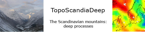
In TopoScandiaDeep project, we will study the composition and properties of the crust and upper mantle below Southern Scandinavia to try to understand why it was uplifted. This will be done using tomographic methods which give an image of the Interior of the Earth by using waves generated by earthquakes or by man-made small surface explosions. We will also use the gravity field, magnetic field and surface heat flow to help constrain the physical properties of the Earth. Finally, the model will be used to test with computer simulations and with tank experiments which forces are necessary to deform the crust and mantle in the way we observe it today in Scandinavia.
Funding
The project is one of 10 projects in the ESF Eurocores programme TOPO-EUROPE. It is funded by the Research Council of Norway, the Danish Agency for Science, Technology and Innovation, Deutsche Forschungsgemeinschaft and Statoil, and runs from the end of 2008 to 2012.
Published Nov. 10, 2010 2:54 PM
- Last modified July 3, 2023 11:54 AM