Booking and prices
Prices: Contact Luc Girod
Booking: Booking through BookitLab
Other enquiries:
drone-lab@mn.uio.no
Contact information:
Facility Manager: Trond Eiken
Location: Sem Sælands vei 1
0371 OSLO
Norway
Instruments / Drones / Processing:
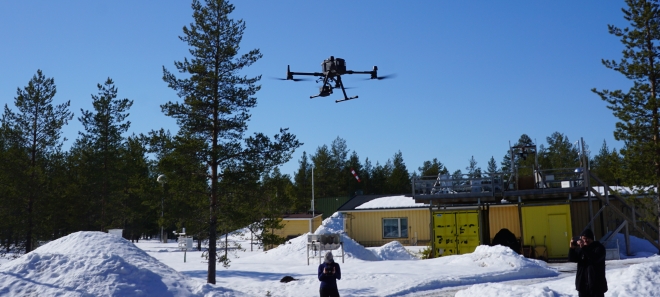
- The equipment in the The Drone Infrastructure Lab ranges from very light drones (DJI Mavic and Phantom series) that are easy to transport and deploy in the field, to much larger systems (DJI Matrice 300RTK and fixed wing Trinity F90+) capable of carrying heavier payloads, including custom systems. Currently available payloads include high precision photogrammetric cameras (DJI P1), thermal cameras (DJI Mavic 2EA and DJI H20T), multispectral cameras (Micasense RedEdge MX Red and Blue), a LiDAR (DJI L1) and a gas analyzer.
- More specific technical and detailed information regarding the drone systems in the lab is available from this wiki-website:
- Support equipment for the lab such as GNSS surveying equipment and control point markers are also available at the Department of Geosciences.
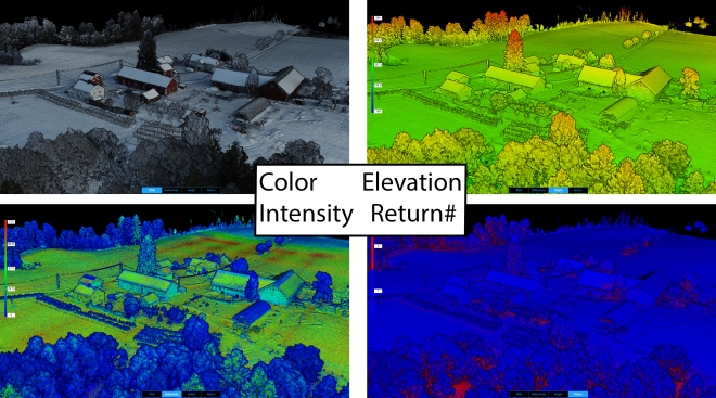
- Available software for processing the data and drone images includes:
- Agisoft Photoscan, Trimble UAS-Master, Pix-4Dmapper, DJI-Terra, as well as open source programs.
Description of services:
-
Users can upon request hire our systems for aerial imagery, photogrammetric data collection, or small-scale earth surface observation.
-
For more complex data collection, users can consult with us on our expertise on lidar, thermal or multi-spectral imagery and/or larger-scale mapping.
-
We can also offer a complete line of work from field planning, acquisition of ground control points, flying and post-processing with deliverables in agreed formats.
The DroneLab@UiO as a core infrastructure
The DroneLab@UiO is a core infrastructure in the Faculty of Mathematics and Natural Sciences. We offer expertise in the field of drone-based remote sensing along with the loan of different drones and payloads to research staff and students at the University of Oslo. The lab is hosted by the Dept. of Geosciences in cooperation with other departments at the Faculty of Mathematics and Natural Sciences.
The DroneLab@UiO gives possibilities for research groups at the MN-faculty, UiO to:
- Perform land surveying and observation missions to advance the understanding of landforms, vegetation, fauna, cryospheric processes, and other fields of interest.
- Study atmospheric conditions such as gas fluxes and turbulence.
- Provide great tools to create impactful visuals for research projects.
If this sounds interesting and you want to know more you can talk to the person responsible, Dr Luc Girod, in room 204 OR read more on the link below.
Wiki page for the DroneLab@UiO
By appointment, the Drone Infrastructure Lab staff can assist in research activities or/and assist students at the Faculty of Mathematics and Natural Sciences, as well as external research institutes.
Some images from the Drone Lab


