Science of sub-surface CO2 storage derives mainly from small scale projects with injections in human time-scales. Projects not been operational long enough to fully assess flow and/or seepage at longer time scales relevant for subsurface CO2 sequestration (e.g. > 10 kY). A critical concern in CCS is how to account for features that are detrimental to subsurface storage containment and are at scales below seismic resolution, such as seeps along faults. With COTEC we aim to get better knowledge about CO2 containment and monitoring techniques.
Fig. 1 – The COTEC project will mainly focus on the Little Grand Wash Fault south of Green River, Utah (yellow square), in the vicinity of the San Rafael Swell Monocline (Modified from Zuchuat et al. 2019a). | See large map 1000px.
About the project
The impacts of Carbon Capture and Storage (CCS) on mitigating climate change appears more and more crucial (Bui et al., 2018), and Norway has become, over the past decade, one of the leading nations with respect to subsurface CO2 storage, due in part to its high-level competence in characterization of sub-surface reservoirs.
Reservoirs in the North Sea are matured for CO2 storage; however, key questions around plume migration mechanisms and pressure linked to site integrity have been raised for both the Sleiper and Snøhvit cases, as well as for the Longyearbyen CO2 lab and Svelvik pilots. Many examples of fluid escape have been documented in the offshore subsurface environment (e.g. seismic chimneys), and active or relict natural seeps on land offer informative analogues to subsurface fluid migration.
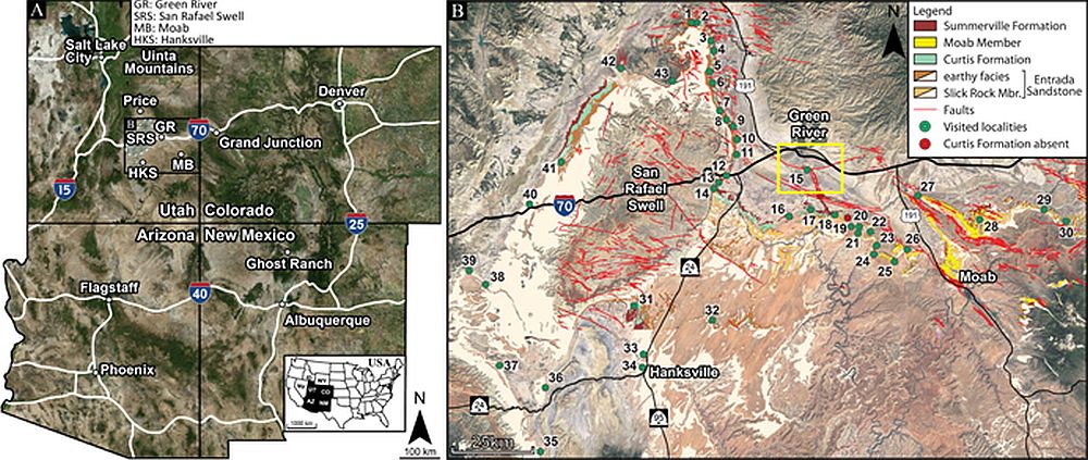
Of note are the natural seeps in east-central Utah, USA (Fig. 1) that are easily accessible and represent suitable onshore counterparts to the offshore fluid escape features, with a specific focus on the Little Grand Wash Fault by Crystal Geyser (Fig. 2), a few kilometres south of Green River. Analysis of these seeps will improve our understanding of geological and geomechanical factors controlling subsurface CO2 containment and the expression of fluid escape in geophysical images.
Fig. 2 – CO2 has been leaking along the Little Grand Wash Fault in east-central Utah for the past 114 kyr at least, resulting in the near-surface precipitation of travertine, as visible on this geomodel. The schematic A-A’ cross-section illustrate the impact of the Little Grand Wash Fault on the Jurassic and Cretaceous stratigraphy of the area. Larger legend 1000px.
Objectives
The multidisciplinary COTEC-project will address the challenge by collecting surface and subsurface datasets at mesoscopic scales that, through upscaling, will be implemented in seismic investigations and reservoir-seal models (Fig. 3).
Fig. 3 – Acquisition of a seismic refraction profile across the Little Grand Wash Fault, east-central Utah, view to the South. Photo: Ivar Midtkandal
The project builds upon previous studies (COPASS project; Skurtveit et al., 2017; Sundal, 2017; Midtkandal et al 2018; Zuchuat et al. 2018; 2019a; 2019b) but is also relevant for analogous settings such as the Norwegian Continental Shelf (e.g. e.g. Aurora and Smeaheia CO2 storage prospects, offshore Norway).
Overall, this next research phase specifically focuses on the detailed, post-depositional history of the Jurassic interval in east-central Utah, addressing one fundamental question: what are the thresholds for detecting CO2 seeps in the subsurface? This encompasses more targeted questions:
What does the fault core and the fault damage zone of the leaking Little Grand Wash Fault consist of?
What is the detailed geological footprint of CO2 flow along strata, faults, and fractures?
How did the CO2 flow migrate through a heterogeneous and transitional, faulted reservoir-seal complex?
Can seepage from the storage compartments and fluid saturation be identified by seismic imaging?
Financing
The COTEC-project was granted financing from the Norwegian Research Council in the CLIMIT-porgramme. This project is also linked to other ongoing research activity in Norway and the USA, and there is a close association toward other Norwegian and US-based federal and private funds. The NFR grant/project number is 295061.
The project timeframe is from from May 2019, with 4 years duration, ending in 2023.
Zuchuat, Valentin; Steel, Elisabeth; Mulligan, Ryan P. & Green, M. J
(2022).
Tidal dynamics in palaeo-seas in response to long-term changes in bathymetry, tidal forcing, and bottom shear stress.
Sedimentology.
ISSN 0037-0746.
doi: 10.1111/sed.12975.
Fracture stiffness and flow properties have been measured in the laboratory using naturally fractured fault rock samples from the Little Grand Wash fault, Utah, USA. We compare fracture closure and related flow change during isotropic loading of two fractures which have been subject to various amounts of paleo‐reactive flow. The two tested fractures are described as (i) a small‐aperture fracture (0.1 mm) with negligible geochemical alterations of the fracture surface and (ii) a large‐aperture fracture (0.53 mm) where precipitates are observed on the fracture surface. X‐ray imaging is used for quantification of fracture aperture and fracture surface contact distribution. The petrographical characterisation using scanning electron microscopy and x‐ray powder diffraction is performed pre‐test and describes burial and uplift diagenesis as well as pulses of reactive fluid flow within the fault. The stress dependent flow and deformation experiment provides new data on fracture stiffness and flow for naturally developed fractures in siliciclastic rock. Fracture stiffness is found to be highest for the small‐aperture fracture due to its high fracture contact ratio and well‐developed surface mating during closure. For the naturally altered and rougher, large‐aperture fracture, fracture stiffness is lower and a highly stress dependent decay in flow is observed during initial closure. The results illustrate that a natural fracture with high contact ratio and well mated surfaces will close during loading, whereas a fracture associated with high flow rates and affected by previous geochemical alteration maintains a high flow rate compared to the host rock during similar loading.
Zuchuat, Valentin; Midtkandal, Ivar; Poyatos More, Miquel; Da Costa, Sigrid; Brooks, Hannah Louise & Halvorsen, Kristine
[Show all 9 contributors for this article](2019).
Composite and diachronous stratigraphic surfaces in low-gradient, transitional settings: The J-3 “unconformity” and the Curtis Formation, east-central Utah, U.S.A.
Journal of Sedimentary Research.
ISSN 1527-1404.
89(11),
p. 1075–1095.
doi: 10.2110/jsr.2019.56.
Full text in Research ArchiveShow summary
Unconformities, by definition, correspond to erosional or nondepositional surfaces, which separate older
strata below, from younger rocks above, encapsulating significant time gaps. However, recent studies have highlighted the composite nature of some unconformities, as well as their heterochronous and diachronous character, which challenge the use of such a definition in a four-dimensional dynamic environment. The J-3 Unconformity, separating the Middle Jurassic Entrada Sandstone from the Upper Jurassic Curtis Formation (and laterally equivalent units) in east-central Utah (USA), is laterally variable, generated by either erosion-related processes such as eolian deflation, and water-induced erosion, or by deformational processes. The J-3 Unconformity is a composite surface, formed by numerous processes that interacted and overlapped spatially and temporally. This study therefore demonstrates the heterochronous, diachronous, and non-unique nature of this surface interpreted as unconformity, where one process can be represented by varying expressions in the stratigraphic record, and conversely many processes may result in the same stratigraphic expression.
Fan, Changyu; Braathen, Alvar; Wang, Zhenliang; Zhang, Xiaoqiang; Chen, Suiying & Feng, Nana
[Show all 8 contributors for this article](2019).
Flow pathway and evolution of water and oil along reverse faults in the northwestern Sichuan Basin, China.
American Association of Petroleum Geologists Bulletin.
ISSN 0149-1423.
103(5),
p. 1153–1177.
doi: 10.1306/10261816501.
Fan, Changyu & Braathen, Alvar
(2019).
Flow of brine and oil along reverse faults in the northwestern Sichuan Basin, China.
American Association of Petroleum Geologists Bulletin.
ISSN 0149-1423.
103(5),
p. 1153–1177.
doi: 10.1306/10261816501.
Zuchuat, Valentin; Steel, Elisabeth; Mulligan, Ryan P.; Collins, Daniel S. & Green, J.A. Mattias
(2021).
Ancient tides and physiography: time to update sequence-stratigraphic models? Show summary
Tidal dynamics are dependent on the physiography (geometry and bathymetry) of a basin and its latitude. By studying the impact that changes in physiography have on tides, scientists can improve their understanding of sedimentary processes that occurred in palaeo-seas, and incorporate potential variations in tidal dynamics in response to relative sea level changes to their interpretation.
We developed a workflow that everyone can use to model the propagation of tides in ancient basins, to understand the evolution of tidal dynamics in a basin with respect to change in its physiography, or to test the feasibility of certain geological interpretations. This methods was tested in the epicontinental Upper Jurassic Sundance and Curtis Seas, which extended from today’s British Columbia to today’s east-central Utah, where tidal currents strongly impacted the deposition of certain sedimentary units preserved in the rock record.
The numerical simulations of tides were run in the open-source Delft3D software by Deltares, and one of the initial input that the software requires is palaeobathymetric data. Because palaeobathymetry data might not exist for the study of ancient seaways, we developed a simple Python code that extracts the colour-value of every pixel in a georeferenced image, before attributing it a depth value depending on how light- or dark-colour the pixel was: the lighter-coloured the pixel is, the shallower the attributed depth is (and vice-versa).
The results of numerical modelling of tidal propagation show that changing the palaeophysiographic configuration of the basin controls both the magnitude and the location of tidal amplification. Some palaeophysiographic configurations resulted in an overall increase in tidal amplitude in the seaway (with various degrees of amplification) but potentially link to the onset of resonance in (part of) the basin, whereas other palaeophysiographic configurations led to a general decrease of the tidal amplitude. Further, certain palaeophysiographic configurations resulted in a heterogeneous spatial distribution of the tidal amplification across the basin as additional tidal harmonics only appeared in certain parts of the basin, but were absent from others. This results in the resurgence of tidal amplification or dampening with different periods at different locations, with increasing spatial variations the deeper the basin is. As a result, the stacking pattern of the various architectural elements would differ from one margin of the basin to the other, despite a similar relative sea-level history. Consequently, the interpretation of the relative sea-level history across an entire basin necessitates caution when tides are one of the main process active at the time of deposition, especially when data points are scarce or limited to a portion of the basin only.
Yelton, Jonathan & Liberty, Lee
(2021).
Seismic Imaging of Active and Ancient CO2 Pathways in the Little Grand Wash Fault.
Zuchuat, Valentin; Midtkandal, Ivar; Poyatos More, Miquel; Da Costa, Sigrid; Brooks, Hannah Louise & Halvorsen, Kristine
[Show all 9 contributors for this article](2021).
Mind The Gap: Composite and diachronous stratigraphic surfaces in low-gradient, transitional settings: The J-3 “unconformity” and the Curtis Formation, east-central Utah, U.S.A.
Zuchuat, Valentin; Steel, Elisabeth; Mulligan, Ryan P.; Collins, Daniel S. & Green, J.A. Mattias
(2021).
A quick a robust numerical modelling method to study the propagation of tides in palaeo-seas.
Show summary
Tidal dynamics in shoreline-shelf systems are dependent on the physiography (geometry and bathymetry) of a basin and its latitude. Researchers can increase their understanding of sedimentary processes in ancient shallow-marine basins, and incorporate potential variations in tidal dynamics in response to an anthropogenically-driven relative sea level change by studying the impact that changes in physiography have on tides.
In order to conduct such an analysis in the epicontinental Upper Jurassic Sundance and Curtis Seas, we developed a workflow that everyone can use to model the propagation of tides in ancient basins, to understand the evolution of tidal dynamics in a basin with respect to change in its physiography, or to test the feasibility of certain geological interpretations.
The numerical simulations of tides are run in the open-source Deltares Delft3D software, and one of the primary input that the software requires is palaeobathymetric data. Since these data might not exist for the study of ancient marine systems, we developed a simple Python code that extracts the colour-value of every pixel in a georeferenced image, before attributing it a depth value depending on how light- or dark-colour the pixel was: the lighter-coloured the pixel is, the shallower the attributed depth is (and vice-versa). Various tidal constituents can then be forced into the system, either at the same time, if the control on the different tidal constituents in the system is robust, or individually in order for example to minimise assumptions. Such a workflow can quickly test if and how tides can propagate in any given ancient seas, which allows for the testing of certain geological interpretation of the rock record.
Our Python-code allows for the very quick generation of multiple palaeobathymetries, by varying the maximum depth attributed to the darkest-coloured pixel of the image, which can then be used to study by proxy the impact of relative sea-level variations on the propagation of tides in ancient seas. The sensitivity of the models can then be tested by varying different input parameters, such as the initial open-ocean tidal forcing, or the bottom drag coefficient values.
Delft3d can notably simulate the tidal amplitude and the flow speed anywhere in the system and at any time, but the distribution of sedimentary facies can be predicted for each of the simulation, using the modelled maximum bed shear stress as a proxy. The map of the predicted distribution of sedimentary facies can then be compared to the real distribution of sedimentary facies in the rock record.
The study of the Upper Jurassic Sundance and Curtis Sea using this simple but robust workflow allowed us to identify the primary control that the physiographic configuration had on the propagation of tides in the system. This workflow also allowed quantifying how tidal dynamics would evolve with respect to change in palaeophysiographic configuration, which has highlighted the importance of considers the effects of palaeophysiographic changes related to relative sea-level variations and their associated impact on tidal dynamics, which will certainly help improving and refining models of tide-dominated basins and their evolution.
Zuchuat, Valentin; Steel, Elisabeth; Mulligan, Ryan P.; Collins, Daniel S. & Green, J.A. Mattias
(2021).
Variations in physiography, tidal forcing, and bottom shear stress in palaeo-seas: lessons learned from numerical modelling.
Show summary
The physiography (geometry and bathymetry) of a basin and its latitude are the primary parameters that dictate the tidal dynamics in shoreline–shelf systems. Understanding the impact that changes in physiography have on tides allows researchers to 1) improve interpretations of historical sedimentary processes in shallow-marine basins, and 2) better predict potential variations in tidal dynamics in response to an anthropogenic-driven relative sea level change.
Here, we present an analysis of numerical modelling of tidal propagation in the Upper Jurassic Sundance and Curtis Seas demontrating that basin-scale amplification and dampening of tides occurred in different palaeophysiographic configurations, and more localised amplification relating to tidal harmonics occurred in certain physiographic scenarios. Consequently, palaeophysiography was the primary control on both the magnitude and location of tidal amplification, flow speed, and bed shear stress, whereas secondary controls were initial tidal forcing and bottom drag coefficient.
Simulation results for the palaeophysiography with a 600 m depth at the mouth of the system suggest a distribution of sedimentary facies comparable to those documented in the Upper Jurassic lower Curtis Formation, apart from the innermost Curtis Sea, near to the palaeoshoreline. Sediments potentially supplied by aeolian processes during regression and increased aridity were likely reworked by tides during a subsequent a transgression as the climate became more humid. The palaeophysiography with a 600 m depth at the mouth of the system can therefore be considered a realistic palaeophysiographic configuration for the Sundance and Curtis Seas given the similarities that exist between the predicted distribution of sedimentary facies and their actual distribution in the lower Curtis Formation. In this palaeophysiography, the Sundance Sea and the Curtis Sea would have thus attained a maximum depth of ~240 m and 40-45 m, respectively. In this context, the simulated tidal range in the Curtis Sea would have reached 2.60 m, which would classify the Curtis Sea as a meso-tidal system (2x 1.30 m tidal amplitude).
Finally, using change in palaeophysiographic configuration as a proxy for relative sea-level variations revealed the non-uniqueness (sensu Burgess & Prince, 2015) of sedimentary successions deposited in tide-dominated basin, given that tidal amplification in the system was controlled by palaeophysiographic configuration: one specific succession could be the product of several, equally-valid relative sea-level histories. Reciprocally, the impact of relative sea-level change on different successions is non-unique, since local tidal harmonics and the characteristics of coeval deposition may vary significantly during relative sea level changes.
Slivicki, Stephen & Liberty, Lee
(2021).
Seismic Response of Natural CO2 Gas Migration Through the Little Grand Wash Fault, Utah.
Zuchuat, Valentin; Steel, Elisabeth; Mulligan, Ryan P.; Collins, Daniel S. & Green, Mattias J.A.
(2021).
Curtis Wars, episode IV: Return of the (Je)tide: Tidal dynamics in palaeo-seas in response to long-term changes in bathymetry, tidal forcing, and bottom shear stress.
Zuchuat, Valentin; Liberty, Lee; Petrie, Elizabeth; Hafner, Alison; Arvesen, Brock & Alterskjær, Camilla
[Show all 10 contributors for this article](2021).
On CO2 monitoring techniques and the importance of collaborating during times of crisis.
Midtkandal, Ivar; Zuchuat, Valentin; Petrie, Elizabeth & Liberty, Lee
(2021).
COTEC.
Show summary
The multi-disciplinary, multi-institution approach to monitoring CO2-flow in the subsurface is presented, and represented by examples from sedimentology, structural geology, and seismic monitoring.
Zuchuat, Valentin; Hafner, Alison; Osmond, Johnathon L.; Liberty, Lee; Petrie, Elizabeth & Arvesen, Brock
[Show all 11 contributors for this article](2020).
CO2 containment and monitoring techniques along Little Grand Wash Fault, east-central Utah, USA.
Zuchuat, Valentin; Sleveland, Arve; Sprinkel, Douglas; Pettigrew, Ross P.; Dodd, Thomas J.H. & Clarke, Stuart M.
[Show all 8 contributors for this article](2020).
When Utah was a blue state: the sedimentology of the tidally-influenced Upper Jurassic Curtis Formation.
Show summary
The sedimentary record of east-central Utah during the Middle/Late Jurassic shows that arid conditions prevailed, punctuated by episodic incursions of the Sundance Sea from the north. It is some of these incursions that terminated the Entrada aeolian system, and deposited the overlying shallow-marine Curtis Formation in a tide-dominated, semi-enclosed basin. The shallow-marine system was neighboured by a coastal aeolian system belonging to the Moab Member of the Curtis Formation, and a fluvially-starved, sporadically-flooded, paralic belt of the Summerville Formation. These paralic deposits progressively blanketed the shallow-marine strata of the Curtis Formation as the sea regressed northward. This study deconstructs and analyses the continental to shallow-marine deposition during one transgressive-regressive cycle.
Our analysis sub-divides the Curtis Formation into three informal units: the lower, middle and upper Curtis. Allocyclically-driven, short-lived relative sea-level variations, along with episodes of uplift and deformation, dominated over autocyclic processes of the Curtis Sea as the lower Curtis was deposited. The system entered into tidal resonance following the onset of the major transgression that defines the base of the middle Curtis, as the flooded basin reached an optimal length that corresponded to an odd multiple of one quarter tidal wavelength. This high-energy resonant system overprinted the effects of allocyclic forcing within the middle Curtis. By contrast, the neighbouring coastal systems continued to record allocyclic signals preserved as five stacked aeolian sequences of the Moab Member of the Curtis Formation, and a cyclical pattern recognised within the supratidal Summerville Formation.
By documenting a resonant stage in a tide-influenced basin that overprints the otherwise dominant allocyclic processes, this study highlights the importance of assessing coeval depositional systems in order to build complete stratigraphic basin histories.
Keywords: allocyclic, autocyclic, Curtis Formation, stratigraphic surfaces, tidal resonance, aeolian sequences, Utah.
Zuchuat, Valentin; Midtkandal, Ivar; Poyatos More, Miquel; Da Costa, Sigrid; Brooks, Hannah L & Halvorsen, Kristine
[Show all 9 contributors for this article](2020).
Brexit, Megxit, and the J-3 Unconformitexit: how they all lost it. Show summary
Unconformities, by definition, correspond to non-depositional or erosive surfaces, separating older strata below, from younger rocks above, and encapsulating significant time gaps. However, recent studies have emphasized the composite nature of some unconformities, as well as their heterochronous and diachronous character, which restricts the use of such a definition to a near one-dimensional setting.
This study analyses the nature of the J-3 Unconformity, which separates the Middle Jurassic Entrada Sandstone from the Late Jurassic Curtis Formation (and laterally equivalent units) in east-central Utah (USA). Our detailed mapping and characterization indicates the J-3 “Unconformity” is in fact a composite surface generated by either erosion-related processes such as eolian deflation, and water-induced erosion, or by deformational processes. These multiple mechanisms interacted and overlapped in time and space, which demonstrates the composite and diachronous and non-unique nature of such boundaries. This contact has been historically interpreted as an unconformity, but our results show that this key stratigraphic surface is a time-transgressive flooding-ravinement surface that formed shortly before and during a series of transgressions that flooded the area during the Late Jurassic. Consequently, the regionally extensive, composite, heterochronous, and diachronous J-3 Unconformity does not fit the classic unconformity definition, after which an unconformity universally separates older from younger strata basin-wide.
The J3 “Unconformity” case study highlights the fact that one process can be represented by varying expressions in the stratigraphic record, and conversely many processes may result in the same stratigraphic expression. Consequently a revised definition of unconformity is discussed, focusing on processes and associated environmental changes, while abandoning its time-barrier aspect. This investigation also exemplifies some of the implications on subsurface analyses that the inaccurate characterization of the subseismic complex characters of such major stratigraphic bounding surfaces can have. These inaccuracies may lead to imprecise timing and sediment budget predictions, and ultimately have strong implications for basin evolution and reservoir models.
Key words: Unconformity, transitional basin, composite surface, ravinement, time-transgressive
Zuchuat, Valentin
(2020).
If Cream knew how to code: psychedelic simulations of tides in the Proto-Western Interior Seaway.
Faleide, Thea Sveva; Braathen, Alvar; Lecomte, Isabelle; Mulrooney, Mark Joseph; Anell, Ingrid Margareta & Midtkandal, Ivar
[Show all 7 contributors for this article](2020).
Testing seismic interpretation of faults by modelling; viable geometries versus seismic resolution in the subsurface.
EAGE extended abstracts.
2020.
doi: 10.3997/2214-4609.202011930.
Faleide, Thea Sveva; Braathen, Alvar; Lecomte, Isabelle; Anell, Ingrid Margareta; Midtkandal, Ivar & Planke, Sverre
(2020).
Seismic modelling of faults; viable geometries vs seismic resolution in the subsurface.
Show summary
Resolution and illumination issues in seismic data curtails identification of fault geometries and fault-initiated rock damage when mapping subsurface faults. Seismic modelling can be utilized to bridge the gap in identifying what can be imaged with certainty in seismic data, with respect to the original geology, especially when also comparing to outcrop data. In this study, we explore how seismic modelling can distinguish between real structures versus seismic artefacts. 2(3)D Point-Spread-Function based convolution modelling is used in a sensitivity study. One input is detailed fault interpretations of high-resolution P-Cable data and comparable conventional 3D seismic data from the Hoop area in the Barents Sea. Another dataset comes from detailed fault geometries observed in outcrops, which were used to build geological models as input to the seismic modelling. In addition to the host-rock lithofacies, parameters of importance for the geological model building include overall fault geometry and the distribution of architectural elements (fault facies) within the fault zone. By varying fault input, lithofacies, a wide range of frequencies, and illumination, we analyse a variety of synthetic seismic images. Finally we compare our modelled outcomes with seismic data from the Hoop area. The scope of the workflow is to increase confidence in seismic interpretations and to identify limitations in the analysis of steep, normal faults in seismic data.
Buckley, Simon John; Ringdal, Kari; Lecomte, Isabelle; Anell, Ingrid Margareta & Braathen, Alvar
(2020).
Virtual field trip to seismic scale outcrops of the Triassic, Edgeøya, Svalbard.
Zuchuat, Valentin; Braathen, Alvar; Midtkandal, Ivar; Liberty, Lee; Skurtveit, Elin & Evans, James R.
[Show all 10 contributors for this article](2020).
COTEC students seminar.
Zuchuat, Valentin; Steel, Elisabeth; Mulligan, Ryan P.; Collins, Daniel S. & Green, Mattias J.A.
(2020).
Does it still make sense to apply classical, sequence-stratigraphical concepts to tide-dominated basins?
Faleide, Thea Sveva
(2020).
Seismic modelling of faults; viable geometries vs seismic resolution in the subsurface.
Faleide, Thea Sveva; Midtkandal, Ivar; Planke, Sverre; Corseri, Romain; Faleide, Jan Inge & Nystuen, Johan Petter
[Show all 7 contributors for this article](2019).
Barremian delta and Early Cretaceous faulting revealed by high resolution 3D seismic data in the southwestern Barents Sea.
NGF Abstracts and Proceedings of the Geological Society of Norway.
Zuchuat, Valentin; Osmond, Johnathon L.; Sundal, Anja; Midtkandal, Ivar; Skurtveit, Elin & Petrie, Elizabeth
[Show all 9 contributors for this article](2019).
CO2 containment and monitoring techniques along Little Grand Wash Fault, east-central Utah, USA.
Show summary
Our current understanding of sub-surface CO2 sequestration feasibility derives mainly from valuable small-scale projects, which have mostly been working at injection or human time scales. These projects, however, have not been operational long enough to fully assess flow and/or seepage at longer time scales relevant for subsurface CO2 storage (e.g. > 10 kY). Many examples of fluid escape have been documented in the offshore subsurface environment (e.g. seismic chimneys), and natural seeps found on land, both active and relict, offer informative analogues to subsurface fluid migration. Of note are the natural seeps located in east-central Utah, USA that are easily accessible and represent suitable onshore counterparts to the offshore fluid escape features. These seeps can improve our understanding of geological and geomechanical factors controlling subsurface CO2 containment and the expression of fluid escape in geophysical images. A critical concern is how to account for features that are detrimental to subsurface storage containment and are at scales below seismic resolution. This multidisciplinary project aims to address the challenge by collecting surface and subsurface datasets at mesoscopic scales that, through viable upscaling, will be implemented in seismic investigations and reservoir-seal models. Moreover, the project builds upon previous studies detailing the complex development of the Jurassic sedimentary basin in question (Zuchuat et al. 2018; 2019; in press) but is also relevant for the Horda Platform region (Aurora and Smeaheia) or other prospective North Sea CO2 storage sites. Overall, this next research phase specifically focuses on the detailed, post-depositional history of the targeted interval in Utah, addressing one fundamental question: what are the thresholds for detecting CO2 seeps in the subsurface? This encompasses more targeted questions:
• What is the detailed geological footprint of CO2 flow along strata, faults, and fractures?
• How did the CO2 flow migrate through a heterogeneous and transitional, faulted reservoir-seal complex?
• Can seepage from the storage compartment be identified by seismic imaging?
• Can detailed geological datasets and related geophysical models verify the existence of – and facilitate quantification of CO2 volumes (saturation) required to create offshore geophysical chimneys, and thereby improve integrity assessment of prospective North Sea CO2 reservoirs?
Zuchuat, V., Sleveland, A. R., Sprinkel, D. A., Rimkus, A., Braathen, A., & Midtkandal, I. (2018). New Insights on the Impact of Tidal Currents on a Low-gradient, Semi-enclosed, Epicontinental Basin—the Curtis Formation, East-central Utah, USA. Geology of the Intermountain West, 5, 131-165.
Zuchuat, V., Sleveland, A.R.N., Pettigrew, R.P, Dodd, T.J.H., Clarke, S.M., Braathen, A., & Midtkandal, I. (2019). Overprinted Allocyclic Processes by Tidal Resonance in an Epicontinental Basin: the Upper Jurassic Curtis Formation, East-Central Utah, USA. The Depositional Record, 5(2), 272-305.
Zuchuat, V., Midtkandal, I., Poyatos-Moré, M., Da Costa, S., Brooks, H.L., Halvorsen, K., Cote, N., Sundal, A., & Braathen, A. (in press.). Composite and Diachronous Stratigraphic Surfaces in Low-Gradient, Transitional Settings: the J-3 “Unconformity” and the Curtis Formation, East-Central Utah, U.S.A. Accepted in The Journal of Sedimentary Research.
Faleide, Thea Sveva; Midtkandal, Ivar; Planke, Sverre; Corseri, Romain; Faleide, Jan Inge & Nystuen, Johan Petter
[Show all 8 contributors for this article](2019).
High-resolution seismic imaging and modelling of structural and stratigraphical features in the SW Barents Sea.
Show summary
Poster at the AAPG 2019 conference, San Antonio, Texas, USA
Zuchuat, Valentin
(2019).
Continental to Shallow Marine Transition in a Tide-Dominated, Low Accommodation basin - Controlling Factors and Depositional Architecture.
University of Oslo.
Full text in Research Archive
Zuchuat, Valentin; Midtkandal, Ivar & Braathen, Alvar
(2019).
Continental to Shallow Marine Transition in a Tide-Dominated, Low Accommodation Basin - Controlling Factors and Depositional Architecture.
University of Oslo.
Show summary
Modern tide-dominated, regressive shorelines featuring deltas estuaries and lagoons are well characterised and distinctive from wave or fluvial dominated systems. However, some ancient tidedominated basins and their associated sedimentary successions do not relate well to any of the above-mentioned, present-day systems. The Utah-Idaho Trough a semi-enclosed, narrow, and shallow foreland basin flooded during the Upper Jurassic by the Curtis Sea is one of these exceptions. The main target of this doctoral thesis is the Upper Jurassic, tide-dominated Curtis Formation, which outcrops in east-Central Utah, where it overlies the Middle Jurassic, aeolian deposits of the Entrada Sandstone. The Curtis Formation is defined at its base by the J-3 Unconformity and is conformably overlain by supratidal sabkha deposits of the Summerville Formation. The Entrada-Curtis-Summerville is subdivided into eight facies associations (FA 1-8), with six subfacies associations (FA 1a, 1b, 3a, 3b, 4a, 4b). Based on the specific three-dimensional arrangement of these facies associations, it is proposed to separate the Curtis Formation into three informal subunits: The lower, middle and upper Curtis. The lower Curtis, which consists of upper shoreface to beach deposits (FA 2), mud- (FA 3a) and sand-dominated heterolithic subtidal flat sediments (FA 3b),
Da Costa, Sigrid; Zuchuat, Valentin & Midtkandal, Ivar
(2018).
The complexity of regional erosion; incision, faulting, and deposition during the development of the J-3 unconformity, Utah, USA.
University of Oslo.
Bromander, Nikoline; Sundal, Anja; Midtkandal, Ivar & Zuchuat, Valentin
(2018).
Facies-controlled reservoir quality and preferential deformation in sandstone reservoirs; a case study from the Entrada Sandstone, Utah, USA.
University of Oslo.
Tveterås, Susanne; Braathen, Alvar; Midtkandal, Ivar & Zuchuat, Valentin
(2018).
Fault style and deformation mechanisms caused by sand mobility in the Entrada Sandstone and Curtis Formation, Utah, USA.
University of Oslo.
Halvorsen, Kristine; Zuchuat, Valentin; Midtkandal, Ivar & Braathen, Alvar
(2018).
Sand tectonics – sand mobility linked to faulting and the influence on depositional systems.
University of Oslo.
Halvorsen, Kristine; Braathen, Alvar; Midtkandal, Ivar & Zuchuat, Valentin
(2018).
Sand tectonics – sand mobility linked to faulting and the influence on depositional systems.
UIO.
Tveterås, Susanne; Braathen, Alvar; Midtkandal, Ivar & Zuchuat, Valentin
(2018).
Fault style and deformation mechanisms caused by sand mobility in the Entrada Sandstone.
UIO.