Vis sammendrag
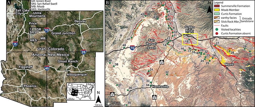
Our current understanding of sub-surface CO2 sequestration feasibility derives mainly from valuable small-scale projects, which have mostly been working at injection or human time scales. These projects, however, have not been operational long enough to fully assess flow and/or seepage at longer time scales relevant for subsurface CO2 storage (e.g. > 10 kY). Many examples of fluid escape have been documented in the offshore subsurface environment (e.g. seismic chimneys), and natural seeps found on land, both active and relict, offer informative analogues to subsurface fluid migration. Of note are the natural seeps located in east-central Utah, USA that are easily accessible and represent suitable onshore counterparts to the offshore fluid escape features. These seeps can improve our understanding of geological and geomechanical factors controlling subsurface CO2 containment and the expression of fluid escape in geophysical images. A critical concern is how to account for features that are detrimental to subsurface storage containment and are at scales below seismic resolution. This multidisciplinary project aims to address the challenge by collecting surface and subsurface datasets at mesoscopic scales that, through viable upscaling, will be implemented in seismic investigations and reservoir-seal models. Moreover, the project builds upon previous studies detailing the complex development of the Jurassic sedimentary basin in question (Zuchuat et al. 2018; 2019; in press) but is also relevant for the Horda Platform region (Aurora and Smeaheia) or other prospective North Sea CO2 storage sites. Overall, this next research phase specifically focuses on the detailed, post-depositional history of the targeted interval in Utah, addressing one fundamental question: what are the thresholds for detecting CO2 seeps in the subsurface? This encompasses more targeted questions:
• What is the detailed geological footprint of CO2 flow along strata, faults, and fractures?
• How did the CO2 flow migrate through a heterogeneous and transitional, faulted reservoir-seal complex?
• Can seepage from the storage compartment be identified by seismic imaging?
• Can detailed geological datasets and related geophysical models verify the existence of – and facilitate quantification of CO2 volumes (saturation) required to create offshore geophysical chimneys, and thereby improve integrity assessment of prospective North Sea CO2 reservoirs?
Zuchuat, V., Sleveland, A. R., Sprinkel, D. A., Rimkus, A., Braathen, A., & Midtkandal, I. (2018). New Insights on the Impact of Tidal Currents on a Low-gradient, Semi-enclosed, Epicontinental Basin—the Curtis Formation, East-central Utah, USA. Geology of the Intermountain West, 5, 131-165.
Zuchuat, V., Sleveland, A.R.N., Pettigrew, R.P, Dodd, T.J.H., Clarke, S.M., Braathen, A., & Midtkandal, I. (2019). Overprinted Allocyclic Processes by Tidal Resonance in an Epicontinental Basin: the Upper Jurassic Curtis Formation, East-Central Utah, USA. The Depositional Record, 5(2), 272-305.
Zuchuat, V., Midtkandal, I., Poyatos-Moré, M., Da Costa, S., Brooks, H.L., Halvorsen, K., Cote, N., Sundal, A., & Braathen, A. (in press.). Composite and Diachronous Stratigraphic Surfaces in Low-Gradient, Transitional Settings: the J-3 “Unconformity” and the Curtis Formation, East-Central Utah, U.S.A. Accepted in The Journal of Sedimentary Research.