About the project
By creating a "time-machine", POLARIS will investigate how the Arctic region has changed over the past 420 Million years. The time-machine requires different types of geological datasets which include information from the Earth's surface but also the deep interior of the Earth.
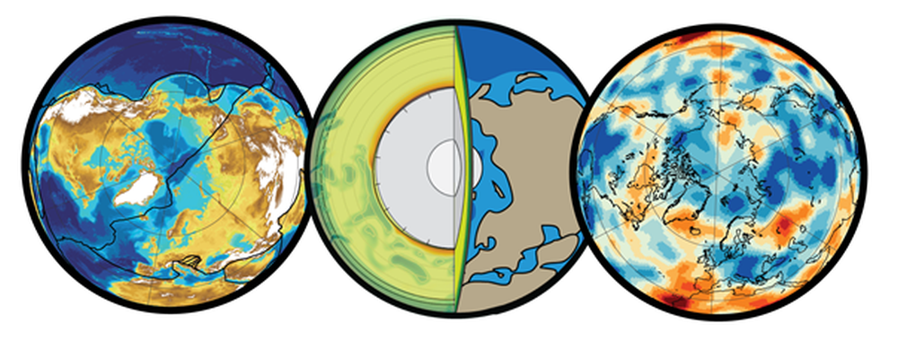
In the research project POLARIS we aim to shift mountains, make oceans appear and disappear, and cause massive volcanic eruptions, all digitally, of course.
The updated project website is at www.polarisdigital.org
Objectives
The main aim of POLARIS is to build an integrated geodynamic simulation model of the circum-Arctic back to the Devonian (ca. 420 Million years ago) with a focus on the interplay of plate tectonics and whole mantle convection. In turn, the simulation models aim to explain large-scale magmatic events and significant paleogeographic changes across the region.
One key objective is to understand the nature of a large igneous province in the Arctic, the High Arctic Large Igneous Province (HALIP), which erupted around 120-85 Million years ago in the central Arctic but is now dispersed across the Canadian Arctic Islands, northern Greenland, Svalbard and Frans Josef Land, the Russian shelf, and under the Arctic ocean.
Background
The geological evolution of the Arctic is as long-lived as it is complicated, and this complexity is a function of its time evolution. Over the last 400+ Million years, the Arctic has experienced extreme terrane mobility, massive volcanic events, and the opening and destruction of oceans. These processes have environmental impacts like mountain building, anoxic ocean events, ice-sheet formation, and mass-extinctions.
To study these interactions, the Arctic must be studied as a unique part of a 4-dimensional whole-Earth domain. However, the spatial connections (including vertically, down to the core boundary, and horizontally over 1000s kms over plates), through to their time-dependent evolution are still poorly understood. This is particularly true for the deep mantle connection, e.g. subducted slabs and mantle plumes, which is particularly underexplored for the Arctic.
POLARIS aims to honour these scales and processes by linking the geodynamic evolution of the deep mantle and surface Arctic.
POLARIS will investigate plate tectonics, mantle convection and magmatism through a framework of synthesising existing data and methods, and generating novel numerical models and analyses.
POLARIS will deliver a self-consistent digital Arctic plate reconstruction back to the Late Paleozoic (~419 Ma), and embed it in global plate reconstructions and generate palaeogeographic maps. The time-dependent mantle connection will be established by exploring Arctic-proximal subduction events and their characteristics including via seismic tomography, forward mantle convection models, and subduction volume estimates (including for True Polar Wander). A plume-origin hypothesis for explaining Arctic Cretaceous magmatism (High Arctic LIP) will be investigated, as well as a controversial link 250 Million year link between the HALIP, the Iceland Plume and the Siberian Traps, and lowermost mantle thermal structures.
Financing
The full name of the project is POLARIS – Evolution of the Arctic in deep time, and it is financed as a FRINATEK – Researcher Project for Young Talents project by the Research Council of Norway/NFR. The project has the project number 326238. The project was awarded to Dr. Grace Elizabeth Shephard, CEED/GEO, UiO.
The project period for POLARISis from 1.12.2021 until 30.11.2025.
For more info please visit https://polarisdigital.org.
Cooperation
- Department of Geosciences, University of Oslo
- The Centre for Earth Evolution and Dynamics, University of Oslo
- Department of Geology, Sonoma State University
- Geological Survey of Canada, Natural Resources Canada