
Model: Earth and Beyond. Illustration: CEED
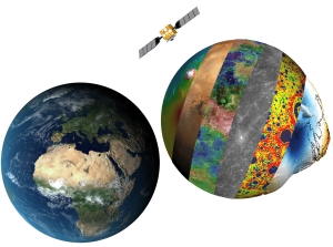
Explanation to graphics: (A) Satellite images and cloud cover mosaic of the Earth. (B) ESA satellite Mars Express. (C) NASA Mars Orbiter Laser Altimeter -derived topography of Mars. (D) NASA Mars Orbiter Camera -derived colored image of Mars. (E) NASA Magellan derived and colored radar altimeter reflectivity map of Venus. (F) NASA Messenger fly-by image of Mercury. (G) NASA GRAIL derived free-air gravity map of the Moon. (H) 3d graph of the exaggerated geoid heights based on the EGM2008, the geoid is a equipotential surface, and would be the shape of the Earth under the influence of gravity if it would ocean everywhere.