Module 1 – Field data sampling, shallow borehole monitoring and local scale modelling (Leader: Ole Humlum)
RT1 is responsible for the field instrumentation and data sampling. Focus is the acquisition of additional high-quality data for addressing the surface and thermal offset processes, and deriving valid factors for the transfer functions used in the equilibrium models. The core of the field instrumentation will be shallow bore holes drilled along a cross-section from the valley to the mountain top, in different topographic and geological settings.
Module 2 – Local-scale numerical modelling (1D, 2D)(Leader: Thomas Vikhamar Schuler)
Simulations of the transient distribution of subsurface temperatures will be carried out using physically-based 1D and 2D transient heat flux models, under development at UiO. We have a fully developed 1D model available, capable of modeling ground temperatures forced by annual, monthly or daily ground surface temperature input values. The model solves the heat flux equations and takes latent heat due to freezing/ thawing into account. The model domain is prescribed in terms of water content, soil density, geothermal heat flux, thermal conductivity and heat capacity.
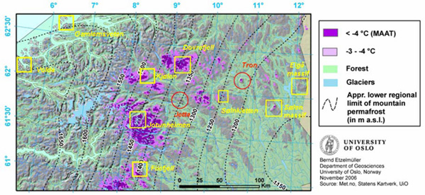
Module 3 – Regional-scale numerical modelling (Leader: Bernd Etzelmüller)
The derivation of snow and soil property factor (Nf, Nt and Rk) spatial fields is the first step, by quantifying the temperature buffering effect of the snow cover (surface offset) driven by the snow model (SMM, NVE/Met.no). We will start with the existing sites for ground surface temperature monitoring. At these sites daily values of SMM-based snow parameters and air temperature will be related to measured ground surface temperatures. We will also apply a simple transient heat conduction model for snow at these sites. Thawing N-factors and the influence of vegetation will be addressed by comparing the gridded air temperatures with measured ground surface temperatures. The topography will be included by means of potential incoming radiation, which is easily calculated over larger areas. Basic data will be available concerning the geology, vegetation and soil in Norge Digital (digital database of Norway about environmental variables). The distribution of block fields, which are important because of cold air ventilation, will be mapped by conventional satellite-based image classification using Landsat VII images. As a second step, we will apply an equilibrium-based spatial model. We will use the SMM to estimate mean snow depth, water equivalent and duration to derive Nf-factor fields. Nt-fields in regions with high topography will be addressed using topography-derived potential radiation fields.