
Disputas og prøveforelesning avholdes digitalt ved bruk av Zoom. Verten av Zoom-møtet vil moderere det tekniske mens disputasleder moderer disputasen. Det er mulig å være tilstede på disputasen i auditorium 1.
Prøveforelesning
Fredag 18 februar, 10:15-11:00, aud 1, Geologibygningen / Zoom:
The influence of global environmental change on the management of high-latitude ecosystems
Kreeringssammendrag
Vegetasjonskart er viktige grunnlag for forvaltning av ressurser og natur, men kan også benyttes i klimaforskning i dynamiske vegetasjonsmodeller. I dette doktorgradsarbeidet er det utviklet statistiske prediksjonsmodeller for utbredelsen av ulike vegetasjonstyper i Norge, hvilke miljøforhold som regulerer utbredelsen og hvordan man kan lage heldekkende vegetasjonskart basert på slike modeller. Arbeidet viser også hvordan klimamodeller basert på parametere fra disse vegetasjonskartene kan utvikles.
Hovedfunn
Populærvitenskapelig artikkel om Horvaths avhandling:
Ecological Climatology and Distribution Modelling
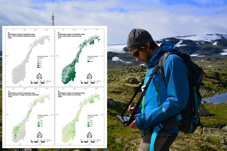
Reliable information about the land surface and vegetation is a prerequisite for managing protected areas, maintaining biodiversity or even predicting climate change. Yet, despite the enormous efforts in field-mapping campaigns, the coverage of vegetation maps in Norway is low. To supplement the coverage of vegetation maps, statistical methods were applied to predict the vegetation distribution. Information about environmental conditions regulating the vegetation distributions were extracted in the process. Moreover, the environmental information about the preferences of each vegetation type was used to improve the ecological components of climate models.
This doctoral thesis (1) presents detailed predictions of vegetation-type distribution for the whole Norway; (2) shows that large-scale landscape patterns are helpful additional information for establishing good predictions; (3) tests ways of assembling wall-to-wall vegetation maps; and (4) improves how vegetation is represented in climate models.
The doctoral work focuses on the Norwegian terrestrial areas, but the methodological findings are applicable to the high-latitude boreal and alpine ecosystems.
Foto og annen informasjon:
Pressefoto: Peter Horvath, portrett; 500px. Foto: Karsten Sund, NHM
Annet bildemateriale: Figur/foto med beskrivelse og kreditering som spesifisert i artikkelen over, størrelse 1600px.