
Disputas og prøveforelesning er i Auditorium 3 i ZEB-bygningen. I noen tilfeller vil prøveforelesning og disputas være mulig å delta på digitalt, i så fall blir det lagt ut en lenke til Zoom.
Prøveforelesning
Tirsdag 20 mai, 10:15-11:00, Aud 3, ZEB-bygningen:
What really controls the uncertainty of the seismic risk?
Kreeringssammendrag
Jordskjelv i byer kan bety fare for bygg og innbyggere. I doktorgradsstudien vurderes seismisk fare og risiko for Oslo, med deterministiske og probabilistiske metoder for konsekvenser for bygg og liv. Federica Ghione har utviklet en fremtidsrettet, rettferdig og systemisk jordskjelvrisikomodell og kombinerer dataanalyser med feltarbeid, som bygningstypologibilder, målinger av forholdet mellom horisontale og vertikale spektra (HVSR) for lokale grunnforhold, samt geologiske undersøkelser av forkastninger. Maskinlæring er brukt for å forbedre eksponeringsmodellen med automatisk identifikasjon av bygningsmaterialer. Fare, eksponering og sårbarhet er vurdert for å gi et helhetlig bilde av seismisk risiko og gi grunnlag for risikoreduserende tiltak, spesielt for områder som tidligere har blitt ansett som seismisk rolige.
Hovedfunn
Populærvitenskapelig artikkel om Ghiones avhandling:
Comprehensive Seismic Hazard and Risk Assessment for Oslo, Norway
Earthquakes pose a potential threat to buildings, infrastructure, and population in urban areas. This doctoral study by Federica Ghione provides a detailed seismic hazard and risk assessment for Oslo (Norway), an area historically considered seismically quiet but still vulnerable due to its geological settings and building stock. The study combines data and information from the different key components (hazard, exposure, and vulnerability) to provide estimates of the seismic risk (see figure).
While Oslo is not prone to large earthquakes, certain areas are more susceptible due to local soil conditions and building types. The research integrates fieldwork and advanced data analysis, including surveys of building typologies, ground conditions, and fault structures, to identify areas with higher seismic risk. The study uses machine learning for building classification and a combined approach based on horizontal-to-vertical spectral ratio measurements and geology-slope estimates to quantify site amplification. Deterministic and probabilistic methods are also employed to provide insights into seismic risk uncertainties.
The findings are crucial for urban planning, guiding better preparedness for potential earthquakes and ensuring that safety standards align with current risks. By identifying vulnerable areas, the research study can help local authorities, policymakers, and city planners make informed decisions for future construction and risk mitigation strategies.
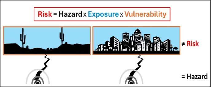
Foto og annen informasjon:
Pressefoto: Federica Ghione, portrett; 1500px. Foto: Privat

Annet bildemateriale: Figur med beskrivelse og kreditering som spesifisert i artikkelen over, størrelse 1000px.
