English
version of this page
SNOWDEPTH – Globale snødybdemålinger fra satellittdata for permafrost, nedbør i høyfjellet og klima-reanalyser
Snø i fjellet er en kilde til drikkevann, vannkraft og irrigasjon, men kan også forårsake flom og geofarer. Det finnes i dag ingen effektive metoder for å måle snødybde i fjell og avsidesliggende områder. Det første målet med dette prosjektet er å kombinere snødybdemålinger fra satellittdata med høydedata, klimadata og statistiske metoder for å utvikle manglende globale snødybdekart. Det andre målet er å bruke de nye kartene til å forbedre globale klimareanalyser og vår kunnskap om høyfjellsnedbør og permafrost.
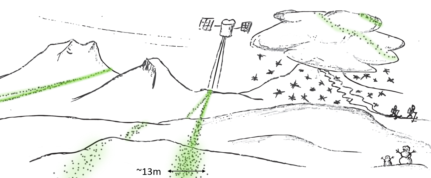
Kunnskap om snødybden i fjellområder er begrenset. Her vises hvordan laser-satellitten ICESat-2 måler høyden til snøoverflaten i seks parallele profiler. I dette forskningsprosjektet vil vi kombinere ulike typer satellittdata, bakkedata og observasjoner i felt for å finne snømasse i forskjellige fjerntliggende områder. Illustrasjon: Désirée Treichler/UiO
Om prosjektet
Dette forskningsprosjektet tar mål av seg som første i verden, å direkte måle snødybder globalt med data av høy romlig oppløsning fra åpne datasett fra ICESat-2 NASA rombårne laserhøydemålingsdata tilgjengelig siden høsten 2018.
For å generere globale månedlige snødybdekart, inkludert for fjellrike og skogkledde områder, vil vi kombinere snødybdedata fra ICESat-2 med data fra ESAs Copernicus Sentinel satellitten over snødekke/dybdedata i et ensemblebasert dataassimilering (DA) rammeverk. Sluttproduktet vil bli tidsserier med snødybdekart for hele verden.
Dette prosjektet har sine hovedsider med mer informasjon om forskning og mål på engelsk.
Les mer om prosjektet på engelske websider.
Finansiering
Dette forskningsprosjektet er finansiert av "ROMFORSK-Programmet for romforskning" fra Norges forskningsråd og gis som et "Forskerprosjekt for unge talenter" til prosjektleder Désirée Treichler. Prosjektnummeret ved NFR er 325519.
Prosjektperioden for SNOWEDEPTH er fra 2021 til 2026.
Samarbeid
Prosjektet er et samarbeid mellomn forskere fra Norge og Sveits fra disse forskningsinstitusjonene:
Publikasjoner
-
Liu, Zhihao; Filhol, Simon & Treichler, Désirée
(2025).
Retrieving snow depth distribution by downscaling ERA5 Reanalysis with ICESat-2 laser altimetry.
Cold Regions Science and Technology.
ISSN 0165-232X.
239.
doi:
10.1016/j.coldregions.2025.104580.
Fulltekst i vitenarkiv
Vis sammendrag
Estimating the variability of snow depth in remote areas poses significant challenges due to limited spatial and temporal data availability. This study uses snow depth measurements from the ICESat-2 satellite laser altimeter, which are sparse in both space and time, and incorporates them with climate reanalysis data into a downscaling-calibration scheme to produce monthly gridded snow depth maps at microscale (10 m). Snow surface elevation measurements from ICESat-2 along profiles are compared to a digital elevation model to determine snow depth at each point. To efficiently turn sparse measurements into snow depth maps, a regression model is fitted to establish a relationship between the retrieved snow depth and the corresponding ERA5 Land snow depth. This relationship, referred to as subgrid variability, is then applied to downscale the monthly ERA5 Land snow depth data. The method can provide timeseries of monthly snow depth maps for the entire ERA5 time range (since 1950). We observe that the generic output should be calibrated by a small number of localized control points from a one-time field survey to reproduce the full snow depth patterns. Results show that snow depth prediction achieved a model fit value of 0.81 (post-calibration) at an intermediate scale (100 m × 500 m) using datasets from airborne laser scanning (ALS) in the Hardangervidda region of southern Norway, with still good results at microscale ( 0.34, RMSE 1.28 m, post-calibration). Bias is greatest for extremes, with very high/low snow depths being under- and overestimated, respectively. Modeled snow depth time series at the site level have a slightly smaller RMSE than ERA5 Land data, but are still consistently biased compared to measurements from meteorological stations. Despite such localized bias and a tendency towards average snow depths the model reproduces the relative snow distribution pattern very accurately, both for peak snow (Spearman’s 0.77) and patchy snow meltout in late spring (Matthews correlation coefficient 0.35). The method relies on globally available data and is applicable to other snow regions above the treeline. Though requiring area-specific calibration, our approach has the potential to provide snow depth maps in areas where no such data exist and can be used to extrapolate existing snow surveys in time and over larger areas. With this, it can offer valuable input data for hydrological, ecological or permafrost modeling tasks.
-
Mazzolini, Marco; Aalstad, Kristoffer; Esteban, Alonso-González,; Westermann, Sebastian & Treichler, Désirée
(2025).
Spatio-temporal snow data assimilation with the ICESat-2 laser altimeter.
The Cryosphere.
ISSN 1994-0416.
19(9),
s. 3831–3848.
doi:
10.5194/tc-19-3831-2025.
Fulltekst i vitenarkiv
Vis sammendrag
The satellite laser altimeter ICESat-2 provides accurate surface elevation observations across the globe. With a high-resolution digital elevation model (DEM), we can use such measurements to retrieve snow depth profiles even in remote areas where snow amounts are poorly constrained. However, the adoption of these retrievals remains low since they are very sparse in space, as the satellite measures along profiles, and in time, as the revisit is 3 months. Data assimilation (DA) methods can exploit snow observations to constrain snow models and provide gap-free distributed simulations. The assimilation of observations related to snow cover is well-established, but there are currently no methods to assimilate sparse ICESat-2 snow depth profiles. We propose an approach that spatially propagates information using – instead of the classic geographical distance – an abstract distance measured in a feature space defined by a topographical index and the melt-out date climatology.
We demonstrate this framework for a small experimental catchment in the Spanish Pyrenees through three experiments. We assimilate different snow observations in an intermediate-complexity snow model: fractional snow-covered area (fSCA) retrievals from Sentinel-2, snow depth profiles from ICESat-2 located in proximity of the catchment or both fSCA and depth in a joint assimilation experiment. Results show that assimilating ICESat-2 snow depth profiles successfully updates the neighbouring unobserved catchment, improving the simulated average snow depth compared to the prior run. Another encouraging finding is that adding the snow depth profiles to fSCA observations leads to an accurate reconstruction of the snow depth spatial distribution. Evaluating the simulations with a set of independent drone-based snow depth maps using a probabilistic skill score, we find that for the accumulation season the joint assimilation's score improves by 19 % the established approach of only assimilating fSCA. The direct but incomplete snow depth information from ICESat-2 is a key constraint on simulated basin-average snow depth.
This study makes use of globally available datasets and shows the promise of adopting ICESat-2's snow depth retrievals in seasonal snow modelling, especially when also assimilating complementary observations. In light of our encouraging results, more research with different experimental designs in varying snow conditions combined with continued methodological development is desirable to further catalyse the use of these retrievals in cryospheric and hydrologic applications.
-
Piermattei, Livia; Zemp, Michael; Sommer, Christian; Brun, Fanny; Braun, Matthias H. & Andreassen, Liss M.
[Vis alle 35 forfattere av denne artikkelen]
(2024).
Observing glacier elevation changes from spaceborne optical and radar sensors - an inter-comparison experiment using ASTER and TanDEM-X data.
The Cryosphere.
ISSN 1994-0416.
18(7),
s. 3195–3230.
doi:
10.5194/tc-18-3195-2024.
Fulltekst i vitenarkiv
Vis sammendrag
Observations of glacier mass changes are key to understanding the response of glaciers to climate change and related impacts, such as regional runoff, ecosystem changes, and global sea level rise. Spaceborne optical and radar sensors make it possible to quantify glacier elevation changes, and thus multi-annual mass changes, on a regional and global scale. However, estimates from a growing number of studies show a wide range of results with differences often beyond uncertainty bounds. Here, we present the outcome of a community-based inter-comparison experiment using spaceborne optical stereo (ASTER) and synthetic aperture radar interferometry (TanDEM-X) data to estimate elevation changes for defined glaciers and target periods that pose different assessment challenges. Using provided or self-processed digital elevation models (DEMs) for five test sites, 12 research groups provided a total of 97 spaceborne elevation-change datasets using various processing approaches. Validation with airborne data showed that using an ensemble estimate is promising to reduce random errors from different instruments and processing methods but still requires a more comprehensive investigation and correction of systematic errors. We found that scene selection, DEM processing, and co-registration have the biggest impact on the results. Other processing steps, such as treating spatial data voids, differences in survey periods, or radar penetration, can still be important for individual cases. Future research should focus on testing different implementations of individual processing steps (e.g. co-registration) and addressing issues related to temporal corrections, radar penetration, glacier area changes, and density conversion. Finally, there is a clear need for our community to develop best practices, use open, reproducible software, and assess overall uncertainty to enhance inter-comparison and empower physical process insights across glacier elevation-change studies.
-
Milkoreit, Manjana; Boyd, Emily; Constantino, Sara M.; Hausner, Vera Helene; Hessen, Dag Olav & Kääb, Andreas
[Vis alle 15 forfattere av denne artikkelen]
(2024).
Governance for Earth system tipping points – A research agenda.
Earth System Governance.
21.
doi:
10.1016/j.esg.2024.100216.
Fulltekst i vitenarkiv
Vis sammendrag
Tipping points in the Earth system could be passed within the Paris Agreement's temperature goal range (1.5°C–2°C). Tipping processes are a feature of complex Earth system dynamics that present major governance challenges not addressed by existing global governance institutions. The common governance toolkit is a poor match for dealing with tipping processes, especially non-linear change, and radical intertemporality. To support the development of effective responses to anticipated, rapid state changes in the Earth system, there is an urgent need for new interdisciplinary research programs focused specifically on tipping-point governance. We distinguish two domains of action in a multi-phase framework - prevention and impact governance - and identify key research areas and questions that need to be addressed. These include developing governance principles, identifying actors and institutions that should be involved or need to be created, and determining the appropriate temporal and spatial scales for governance efforts.
-
Mazzolini, Marco; Aalstad, Kristoffer; Alonso-Gonzalez, Esteban; Westermann, Sebastian & Treichler, Désirée
(2024).
Spatio-temporal snow data assimilation with the ICESat-2 laser altimeter.
The Cryosphere Discussions.
doi:
10.5194/egusphere-2024-1404.
Fulltekst i vitenarkiv
-
Alonso-Gonzalez, Esteban; Aalstad, Kristoffer; Pirk, Norbert; Mazzolini, Marco; Treichler, Désirée & Leclercq, Paul
[Vis alle 9 forfattere av denne artikkelen]
(2023).
Spatio-temporal information propagation using sparse observations in hyper-resolution ensemble-based snow data assimilation.
Hydrology and Earth System Sciences (HESS).
ISSN 1027-5606.
27(24),
s. 4637–4659.
doi:
10.5194/hess-27-4637-2023.
Fulltekst i vitenarkiv
Vis sammendrag
Data assimilation techniques that integrate available observations with snow models have been proposed as a viable option to simultaneously help constrain model uncertainty and add value to observations by improving estimates of the snowpack state. However, the propagation of information from spatially sparse observations in high-resolution simulations remains an under-explored topic. To remedy this, the development of data assimilation techniques that can spread information in space is a crucial step. Herein, we examine the potential of spatio-temporal data assimilation for integrating sparse snow depth observations with hyper-resolution (5 m) snow simulations in the Izas central Pyrenean experimental catchment (Spain). Our experiments were developed using the Multiple Snow Data Assimilation System (MuSA) with new improvements to tackle the spatio-temporal data assimilation. Therein, we used a deterministic ensemble smoother with multiple data assimilation (DES-MDA) with domain localization.
Three different experiments were performed to showcase the capabilities of spatio-temporal information transfer in hyper-resolution snow simulations. Experiment I employed the conventional geographical Euclidean distance to map the similarity between cells. Experiment II utilized the Mahalanobis distance in a multi-dimensional topographic space using terrain parameters extracted from a digital elevation model. Experiment III utilized a more direct mapping of snowpack similarity from a single complete snow depth map together with the easting and northing coordinates. Although all experiments showed a noticeable improvement in the snow patterns in the catchment compared with the deterministic open loop in terms of correlation (r=0.13) and root mean square error (RMSE = 1.11 m), the use of topographical dimensions (Experiment II, r=0.63 and RMSE = 0.89 m) and observations (Experiments III, r=0.92 and RMSE = 0.44 m) largely outperform the simulated patterns in Experiment I (r=0.38 and RMSE = 1.16 m). At the same time, Experiments II and III are considerably more challenging to set up. The results of these experiments can help pave the way for the creation of snow reanalysis and forecasting tools that can seamlessly integrate sparse information from national monitoring networks and high-resolution satellite information.
-
Berthier, Etienne; Floriciou, Dana; Gardner, Alex S.; Gourmelen, Noel; Jakob, Livia & Paul, Frank
[Vis alle 16 forfattere av denne artikkelen]
(2023).
Measuring glacier mass changes from space-a review.
Reports on progress in physics (Print).
ISSN 0034-4885.
86(3).
doi:
10.1088/1361-6633/acaf8e.
Fulltekst i vitenarkiv
Vis sammendrag
Abstract Glaciers distinct from the Greenland and Antarctic ice sheets are currently losing mass rapidly with direct and severe impacts on the habitability of some regions on Earth as glacier meltwater contributes to sea-level rise and alters regional water resources in arid regions. In this review, we present the different techniques developed during the last two decades to measure glacier mass change from space: digital elevation model (DEM) differencing from stereo-imagery and synthetic aperture radar interferometry, laser and radar altimetry and space gravimetry. We illustrate their respective strengths and weaknesses to survey the mass change of a large Arctic ice body, the Vatnajökull Ice Cap (Iceland) and for the steep glaciers of the Everest area (Himalaya). For entire regions, mass change estimates sometimes disagree when a similar technique is applied by different research groups. At global scale, these discrepancies result in mass change estimates varying by 20%–30%. Our review confirms the need for more thorough inter-comparison studies to understand the origin of these differences and to better constrain regional to global glacier mass changes and, ultimately, past and future glacier contribution to sea-level rise.
-
Li, Wei; Chen, Jie; Li, Lu; Orsolini, Yvan J.; Xiang, Yiheng & Senan, Retish
[Vis alle 7 forfattere av denne artikkelen]
(2022).
Impacts of snow assimilation on seasonal snow and meteorological forecasts for the Tibetan Plateau.
The Cryosphere.
ISSN 1994-0416.
16(12),
s. 4985–5000.
doi:
10.5194/tc-16-4985-2022.
Fulltekst i vitenarkiv
Vis sammendrag
The Tibetan Plateau (TP) contains the largest amount of snow outside the polar regions and is the source of many major rivers in Asia. An accurate long-range (i.e. seasonal) meteorological forecast is of great importance for this region. The fifth-generation seasonal forecast system of the European Centre for Medium-Range Weather Forecasts (SEAS5) provides global long-range meteorological forecasts including over the TP. However, SEAS5 uses land initial conditions produced by assimilating Interactive Multisensor Snow and Ice Mapping System (IMS) snow data only below 1500 m altitude, which may affect the forecast skill of SEAS5 over mountainous regions like the TP. To investigate the impacts of snow assimilation on the forecasts of snow, temperature and precipitation, twin ensemble reforecasts are initialized with and without snow assimilation above 1500 m altitude over the TP for spring and summer 2018. Significant changes occur in the springtime. Without snow assimilation, the reforecasts overestimate snow cover and snow depth while underestimating daily temperature over the TP. Compared to satellite-based estimates, precipitation reforecasts perform better in the west TP (WTP) than in the east TP (ETP). With snow assimilation, the reforecasts of snow cover, snow depth and temperature are consistently improved in the TP in the spring. However, the positive bias between the precipitation reforecasts and satellite observations worsens in the ETP. Compared to the experiment with no snow assimilation, the snow assimilation experiment significantly increases temperature and precipitation for the ETP and around the longitude 95∘ E. The higher temperature after snow assimilation, in particular the cold bias reduction after initialization, can be attributed to the effects of a more realistic, decreased snowpack, providing favourable conditions for generating more precipitation. Overall, snow assimilation can improve seasonal forecasts through the interaction between land and atmosphere.
Se alle arbeider i NVA
-
Mazzolini, Marco; Cowherd, Marianne; Aalstad, Kristoffer; Girotto, Manuela; Alonso-González, Esteban & Treichler, Désirée
(2025).
Modelling snow spatial covariances to improve the assimilation of sparse observations.
Fulltekst i vitenarkiv
-
-
Treichler, Désirée; Mazzolini, Marco; Aune, Simen Dalseid; Bühler, Yves; Girod, Luc & Liu, Zhihao
[Vis alle 8 forfattere av denne artikkelen]
(2025).
High-resolution snow depth profiles from ICESat-2.
doi:
https:/lps25.esa.int/lps25-presentations/presentations/316/_316.pdf.
Fulltekst i vitenarkiv
Vis sammendrag
To date, snow depth measurements require manual measurements or targeted field campaigns. The ATLAS sensor onboard the ICESat-2 satellite acquires profiles of surface elevation measurements of very high accuracy. When compared with an accurate digital elevation model (DEM) from snow-free conditions, this data directly translates into snow depth measurements. Previous studies used the spatially summarised ICESat-2 data products ATL06 and ATL08 with an along-profile resolution of 20-100 m. They found that ICESat-2 can provide average snow depth estimates at the watershed scale with decimeter-level uncertainties. Uncertainties and bias were found to strongly increase with slope and depend on the reference DEM accuracy and the quality of the co-registration of the datasets. This study uses the individual photon data product ATL03 that has an along-track resolution of 0.7 m and thus the potential to provide high-resolution snow depth profiles. Each overpass results in a profile pair separated by 90 m laterally and consisting of a weak and a strong beam with approximately four times as many return photons. We compare different photon filtering and co-registration methods for five field sites in Norway, Finland, and Switzerland including alpine terrain of different topography, sparse and dense forest. Given careful pre-processing, we find that ATL03 data can yield snow depth profiles with a few meters' spatial resolution that closely match profiles derived from reference snow depth maps from uncrewed aerial vehicles (UAVs) acquired within 5-10 days of an ICESat-2 overpass. The goodness of fit depends on the chosen filtering method which should be adjusted to the acquisition conditions and the presence of vegetation and snow on trees to yield optimal results. Dataset co-registration is crucial for steep terrain, and in some areas, the strong and weak beam have different spatial offsets that require separate co-registration for each beam. Given locally optimised pre-processing, the uncertainty (mean absolute deviation, MAD) for ICESat-2/UAV data pairs ranges from 0.05 m in a sparsely forested, flat site to 0.4 m in a very steep alpine site. Bias (median residual) ranges from a few centimetres to several decimetres. For most sites the snow depths retrieved from strong and weak beams are consistently offset, with a vertical difference of up to 25 cm between strong/weak snow depth profiles for the same filtering/co-registration method and site, suggesting inconsistencies in the geolocation of beams of the same pair in ATL03 data. Improved low-level processing on the data provider's side in future ATL03 data versions may reduce the differences between the beams. This study finds that, given accurate reference DEMs, ICESat-2 data can not only provide catchment-scale snow depth averages but also high-resolution snow depth profiles in areas where no measurements currently exist, showcasing the potential of spaceborne laser altimetry for providing high-resolution snow depth measurements globally.
-
Mazzolini, Marco; Cowherd, Marianne; Aalstad, Kristoffer; Girotto, Manuela; Alonso-González, Esteban & Treichler, Désirée
(2025).
Data assimilation of sparse snow depth observation with optimized spatial transfer of information.
doi:
https:/lps25.esa.int/programme/programme-session/?id=F04A2D11-A598-4F96-92B0-4652E462A8DD&presentationId=DE10A404-4AA5-40EF-B5CA-0FBDBEE68EE2.
Fulltekst i vitenarkiv
Vis sammendrag
The satellite laser altimeter ICESat-2 provides accurate surface elevation observations across our living planet. With a high-resolution digital elevation model (DEM), we can use such measurements to retrieve snow depth profiles. Such observations are of great societal relevance because water managers could potentially use them to infer snow amounts even in remote montane areas, where the role of snow as water tower is not actively monitored. However, these retrievals are not currently used operationally because they are very sparse in space and time: ICESat-2 measures along profiles with a three-month repeat interval. The high spatio-temporal variability of the seasonal snowpack limits the observations’ value. Data Assimilation (DA) methods allow to use information from snow observations to constrain snow models and provide gap-free distributed simulations. The assimilation of observations like snow cover is considered the state-of-the-art for generating retrospective reanalysis, but the use of sparse snow depth observations in DA is an active research area as those could be used in an operational manner. Covariance localization has been adopted to spatially transfer information from observed locations to similar unobserved locations. Traditionally, the geographical distance has been used to define the similarity between locations. In previous studies, we showed that topographical indices and the climatology of the melt-out date are also relevant parameters for determining the similarity. However, this measure was considered as a fixed hyperparameter. In this work, we exploit airborne lidar snow depth maps acquired by the Airborne Snow Observatory (ASO) to optimize the similarity measure between simulated cells. Gaussian Processes (GP) offer a probabilistic approach to infer the relative relevance of geographic, topographic and snow-climatology variables through a method called Automatic Relevance Determination (ARD). Preliminary results from the East River basin in Colorado, USA, indicate that ARD can successfully learn repeated snow depth patterns from a water year and improve the spatial transfer of information for successive water years when only a profile is measured. The learned relative relevance is used in a set of full spatio-temporal DA experiments designed to quantify the potential contribution of snow depth observations from the satellite altimeter ICESat-2 for seasonal snow operational forecasts.
-
-
Mazzolini, Marco; Aalstad, Kristoffer; Alonso-González, Esteban; Westermann, Sebastian & Treichler, Désirée
(2025).
Spatio-temporal snow data assimilation with the ICESat-2 laser altimeter.
Fulltekst i vitenarkiv
Vis sammendrag
Presentation: methods for spatio-temporal propagation of sparse snow data
-
Tjoflot, Gunn Kristin & Treichler, Désirée
(2025).
Smeltende isbreer øker tapet av ferskvann og hever globale havnivåer.
Titan.uio.no.
Fulltekst i vitenarkiv
-
-
Aalstad, Kristoffer; Alonso-Gonzalez, Esteban; Mazzolini, Marco & Willmes, Clarissa
(2025).
Adventures in snow data assimilation.
Fulltekst i vitenarkiv
Vis sammendrag
In this talk I will provide a guided tour of some of our adventures in snow data assimilation. The role that snow reanalysis can play in filling key observational gaps from both established and emerging Earth observations will be a recurring theme. This will be highlighted through examples from some ongoing work on trying to estimate global seasonal snow water equivalent using optical satellite data. Through our adventures, I hope to showcase the still largely untapped potential that data assimilation holds for adding value to Earth observations and constraining snow model uncertainty.
-
Aalstad, Kristoffer; Blandini, Giulia; Guidicelli, Matteo; Pirk, Norbert & Hove, Alouette van
(2025).
Learning to assimilate and assimilating to learn.
Fulltekst i vitenarkiv
Vis sammendrag
https://www.hydrologiraadet.no/seminar-om-maskinlaering-innen-hydrologi-og-meteorologi-25-april/
-
Aalstad, Kristoffer
(2025).
Fundamentals of Cryospheric Data Assimilation.
Fulltekst i vitenarkiv
Vis sammendrag
https://www.mn.uio.no/geo/english/research/projects/snowdepth/events/cryodaworkshop-oslo.html
-
-
Treichler, Désirée
(2024).
Paneldebatt: populærvitenskapelige spørsmål og svar med NRK's Abels tårn.
Fulltekst i vitenarkiv
Vis sammendrag
Paneldiskusjon ledet av Torkild Jemterud fra Abels tårn (NRK) - nerdige svar på de små og store spørsmål innen forskningsfeltene til paneldeltakere: snø, hjerneceller og solfysikk
-
Treichler, Désirée
(2024).
Å måle snø fra verdensrommet: hvorfor er det relevant forskning?
[Internet].
Naturfagpodden.
Fulltekst i vitenarkiv
-
-
Mazzolini, Marco; Aalstad, Kristoffer; Alonso-Gonzalez, Esteban & Treichler, Désirée
(2024).
Spatio-temporal snow data assimilation with the ICESat-2 laser altimeter.
Fulltekst i vitenarkiv
-
Mazzolini, Marco; Aalstad, Kristoffer; Treichler, Désirée & Alonso-Gonzalez, Esteban
(2024).
Spatio-temporal snow data assimilation with the ICESat-2 laser altimeter.
Fulltekst i vitenarkiv
-
Aalstad, Kristoffer; Willmes, Clarissa; Mazzolini, Marco & Kreynen, Dylan
(2024).
Snow data assimilation at UiO.
Fulltekst i vitenarkiv
-
Treichler, Désirée; Filhol, Simon; Mazzolini, Marco; Yilmaz, Yeliz A. & Silantyeva, Olga
(2024).
UiO’s snow field sites, measurements, remotely sensed datasets, and climate container.
Fulltekst i vitenarkiv
-
Aalstad, Kristoffer; Hock, Regine; Mazzolini, Marco; Pirk, Norbert; Treichler, Désirée & Westermann, Sebastian
[Vis alle 9 forfattere av denne artikkelen]
(2024).
Ensemble-Based Reanalysis of the Terrestrial Cryosphere.
Fulltekst i vitenarkiv
Vis sammendrag
The terrestrial cryosphere in the form of glaciers, permafrost, and seasonal snow, plays a vital role in the climate system by regulating the global cycles of energy, carbon, and water. As a result, these components of the cryosphere are considered essential climate variables (ECVs) by the Global Climate Observing System. At the same time, these ECVs are only partially observable by Earth observing satellites due to gaps, noise, and indirect retrieval algorithms. The statistical fusion of uncertain models and noisy observations referred to as data assimilation in geoscience represents a natural solution to this problem of partial observability. Nonetheless, beyond the confines of weather prediction and atmospheric reanalyses, data assimilation has received relatively little attention in broader Earth system science despite its potential for adding value to observations by filling gaps and inferring latent ECVs with uncertainty quantification.
In this contribution, we present ongoing efforts in several projects applying ensemble-based (probabilistic) data assimilation techniques to carry out long term and large scale reanalyses of the terrestrial cryosphere. Our lofty goals in these projects are to generate global high resolution multi-decadal ensemble-based reanalyses of glacier mass balance, the thermal state of permafrost, and seasonal snow mass. In doing so, we are leveraging a plethora of emerging data from Earth observing satellites, global atmospheric reanalyses, and in-situ observations. Herein, we will focus mainly on the general implementation of the novel ensemble-based methods that we are using to solve the reanalysis (or reconstruction) problem as opposed to the structure of the specific cryospheric models and data that they are applied to. Considerable emphasis is placed on how these methods can be deployed at unprecedented spatio-temporal scales while retaining uncertainty quantification that is crucial in guiding decisions. Looking further ahead, we will highlight the challenges that remain in pushing the boundaries of terrestrial reanalysis efforts towards the hillslope (100 m) scale and making use of the largely untapped and continuously growing stream of Earth observation data.
-
Li, Lu; Li, Wei; Chen, Jie & Orsolini, Yvan Joseph Georges Emile G.
(2023).
Impacts of Snow Assimilation and Dynamic Downscaling on Seasonal Meteorological Forecasts over the Third Pole Region.
Fulltekst i vitenarkiv
-
-
Mazzolini, Marco; Treichler, Désirée; Aalstad, Kristoffer & Alonso-Gonzalez, Esteban
(2023).
Satellite Altimetry as a New Data Source for Snow Depth Data Assimilation.
Fulltekst i vitenarkiv
-
Liu, Zhihao; Treichler, Désirée & Mazzolini, Marco
(2023).
Snow depth retrieval using satellite altimetry, climate reanalysis data and machine learning: A case study in mainland Norway.
Fulltekst i vitenarkiv
-
Treichler, Désirée; Mazzolini, Marco; Liu, Zhihao & Guidicelli, Matteo
(2023).
SNOWDEPTH: Global snow depths from spaceborne remote sensing
for permafrost, high-elevation precipitation, and climate reanalyses.
Fulltekst i vitenarkiv
-
Treichler, Désirée; Mazzolini, Marco; Piermattei, Livia; Webster, Clare; Girod, Luc & Bühler, Yves
(2023).
Spaceborne snow depth measurements from ICESat-2 laser altimetry.
Fulltekst i vitenarkiv
-
Mazzolini, Marco; Aalstad, Kristoffer; Treichler, Désirée & Alonso-Gonzalez, Esteban
(2023).
Spatio-temporal snow data assimilation with laser altimetry.
Fulltekst i vitenarkiv
-
Mazzolini, Marco; Aalstad, Kristoffer; Treichler, Désirée & Alonso-Gonzalez, Esteban
(2023).
Satellite Altimetry for Data Assimilation.
Fulltekst i vitenarkiv
-
Treichler, Désirée; Mazzolini, Marco; Piermattei, Livia; Webster, Clare & Girod, Luc
(2022).
Spaceborne snow depth measurements from ICESat-2 laser altimetry.
Fulltekst i vitenarkiv
-
Treichler, Désirée; Webster, Clare & Aune, Simen Dalseid
(2024).
Snow depth estimation in forested terrain using the ICESat-2 space laser.
Universitetet i Oslo.
Fulltekst i vitenarkiv
Vis sammendrag
NASA’s Ice, Cloud and Land Elevation Satellite-2 (ICESat-2) provides a way to measure terrain heights at a global scale with 91-day repeat intervals in polar regions. ICESat-2’s ATLAS instrument is a photon counting, visible green light (532 nm) Light Detection and Ranging (LiDAR) sensor which measures the Earth surface in six separate beams. An ongoing project at the University of Oslo, SNOWDEPTH, aims to use these measurements to model snow depths at large scale. This thesis will build on — and hopefully contribute to — that work, and aims to assess whether ICESat-2 is able to accurately measure snow surface heights in a boreal forest in Southern Norway. LiDAR is particularly effective at ground surface measurements in forests, due to it’s ability to penetrate canopies and reliance on just a single laser beam to determine positions. While this is a common use case for Airborne Laser Scanning (ALS) and Uncrewed Aerial Vehicle (UAV)-borne LiDAR sensors, space based laser altimetry is less explored. In this thesis, UAV-borne LiDAR has been used to generate control data from a total of four field sites, with a spatial and near-temporal overlap with ICESat-2 measurements. The ICESat-2 data is normalised against Digital Terrain Model (DTM)s from the Norwegian Mapping Authority (NMA), and the resulting snow depths are compared to the UAV control data. To ensure calculations are done on photons reflected from the snow surface, filtering is necessary. Forest canopies are also represented in the data, along with stray photons and photons which have penetrated the snow surface before reflecting. Three methods for photon filtering are compared for their ability to help determine the actual snow surface height, and filter noise. Two of the methods are developed specifically during the work with this thesis, while the third is developed by NASA. The correlation between the canopy cover and height measurement bias within each photon footprint is also examined, to determine the impact canopy cover has on the bias and assess the presence of a causal relationship. Overall, across all the field sites, the NASA developed filtering method was very efficient with a Root Mean Square Error (RMSE) of 0.59 m. The second method was slightly more accurate, with an RMSE of 0.48 m, but relies on additional input data. The third method performed the worst, with an RMSE of 0.72 m. This is an order of magnitude larger than what has been achieved with ICESat-2 in unforested flat terrain, but comparable to at least one study looking at snow depths in sloped, forested terrain.
-
Treichler, Désirée & Liu, Zhihao
(2023).
Snow Depth Retrieval and Downscaling using Satellite Laser Altimetry, Machine Learning, and Climate Reanalysis: A Case Study in Mainland Norway.
Universitetet i Oslo.
Fulltekst i vitenarkiv
Se alle arbeider i NVA
Publisert 27. juni 2022 11:34
- Sist endret 21. des. 2022 14:00