DYPOLE
Dynamics of polar confined basins – The Eurasia Basin from breakup in greenhouse to present in icehouse conditions
Eurasia-bassenget: 3D kart av Eurasia-bassenget, havbunnen er avgrenset av Grønland, Lomonosovryggen og de undersjøiske hyllene til Laptevhavet, Karahavet og Barentshavet. Kartet viser kontinentalmarginen nord for Svalbard/Barentshavet og tilgrensende områder av Polhavet. Illustrasjon Arctic bathymetry (IBCAO, Jakobsson et al. 2020, via GeoMapApp)
Varighet
01.01.2021–31.12.2025
Den arktiske regionen, Norges nabolag, fungerer som en avgjørende indikator på global klimahelse. Å forstå fortiden, spesielt i perioder med rask oppvarming som i dag, er avgjørende for nøyaktige spådommer om fremtidens klima. DYPOLEs forskning kan omforme klimavitenskapen, og tilby ny innsikt i samspillet mellom tektoniske, magmatiske og sedimentære prosesser og deres innvirkning på klimaet.
Kontaktpersoner
Carmen GainaInstitutt for geofag, Universitetet i OsloProfessor og prosjektleder
Gjennom DYPOLE-prosjektet vil vi øke forståelsen av det komplekse samspillet mellom ulike geologiske prosesser som har formet kontinentalmarginen nord for Svalbard/Barentshavet og tilgrensende områder av Polhavet. Sentrale spørsmål som stilles omfatter:
Hvordan sprakk kontinentet opp mellom Lomonosovryggen og Barentssokkelen for ca 55 millioner år siden og hvordan åpnet Polhavet seg etter dette og frem til i dag
Når ble det etablert en dypvannsforbindelse mellom Polhavet og Atlanterhavet gjennom Framstredet, og hvordan påvirket dette geologiske og oseanografiske forhold?
Hvordan har denne utviklingen påvirket klima fra "drivhus" forhold med vanntemperaturer i overflaten på opptil 25°C i et lukket havbasseng til "ishus" forhold med omfattende land- og sjøisdekke de siste 10-15 millioner år?
Når og hvordan ble Barentsokkelen hevet slik at store bergartsvolumer ble høvlet av og transportert ut i Polhavet, der de nå gir oss et unikt arkiv som belyser den geologiske og klimatiske utviklingen gjennom millioner av år?
Disse spørsmålene kan kun besvares tverrfaglig ved bruk av et bredt spekter av data og metoder. Vi studerer geologiske strukturer i dypet som avbildes ved hjelp av seismiske data.
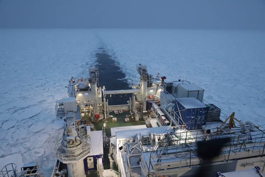
FF Kronprins Haakon på tokt for geofysisk undersøkelser i Polhavet. Bildet viser skipet på det første GoNorth-toktet, tatt 18.10.2022 nord for Svalbard, imøte med sjøisen. Foto: Daniel Albert/GoNorth
Vi prøvetar sedimenter og analyserer deres sammensetning og alder som gjenspeiler detaljer i den geologiske utviklings- og klimahistorien. Noe relevante data finnes, men det er behov for nye og bedre data fra områder som byr på store utfordringer, blant annet på grunn av isforhold.
Resultatene blir sammenlignet med Svalbards geologi som gir oss unik innsikt i Barentssokkelens geologi og utvikling. På Svalbard vil lytteinstrumenter bli utplassert som registrer seismiske bølger fra våre undersøkelser på nordmarginen og i Polhavet, i tillegg til naturlige jordskjelv. Gjennom DYPOLE vil vi øke interessen for og kunnskapen om Polhavet. Vi vil styrke samarbeid både nasjonalt og internasjonalt og bidra til å utdanne neste generasjon polarforskere.
Deltakere
Carmen Gaina
Universitetet i Oslo Professor (marin geofysikk) og prosjektleder
Jan Inge Faleide
Universitetet i Oslo Professor emeritus (marin geofysikk)
Aøexander MinakovInstitutt for geofag og PHABForsker
Juan Camilo Meza CalaInstitutt for geofag og PHABStipendiat
The High Arctic Large Igneous Province (HALIP) is a major tectono-magmatic element that affected large parts of the Arctic during the Cretaceous (magmatism occurred from 126
to 78 million years ago [Ma]). In Svalbard, HALIP intrusive and extrusive rocks are grouped and classified as the Diabasodden Suite. Sills and dykes are present throughout Svalbard, emplaced in units stratigraphically ranging from crystalline basement to Jurassic-Cretaceous siliciclastics. Time-equivalent lava flows are exposed on Kong Karls Land in eastern Svalbard. In this contribution, we firstly define and introduce major features of the circum-Arctic HALIP. Secondly, we zoom into Svalbard where we document and summarize the attributes of HALIP outcrops (i.e., the Diabasodden Suite) located in and around Isfjorden, the most accessible location that is reachable on day trips using boats from Longyearbyen. For each of the 15 sites we focus on specific aspects of HALIP characterization, including geochronology, geochemistry and geometry of volcanic and intrusive rocks. We complement field descriptions of the sites with digital geoscientific data, including digital outcrop models and photospheres. Finally, we synthesize the Isfjorden study area in the context of data and knowledge gaps for the HALIP in general. We hope that this contribution will stimulate further HALIP research in Isfjorden and beyond.
The Greenland Magnetic Map (GREENMAG) is a new compilation of magnetic anomaly data that covers the inland ice, ice-free coastal areas, and adjacent shelf regions of Greenland (https://doi.org/10.22008/FK2/LQN5YJ, Heincke and Szwillus, 2025). GREENMAG is based on all accessible modern regional aeromagnetic surveys from Greenland and vintage datasets without GPS positioning in areas where modern data are lacking. The magnetic anomaly map is generated by a combination of equivalent source (ES) modeling and spherical harmonic expansion. Hereby, the data points are used at their actual measurement location as input data for the inversion of the ES modeling. The equivalent sources are represented by magnetic dipoles that are arranged in three uniform grids with different source spacing and depths (coarsest spacing: 10 × 10 km; medium spacing: 2 × 2 km; finest spacing: 0.7 × 0.7 km). Regularization in the inversion for the different equivalent source grids are chosen such that the resulting resolution is adapted to the largely varying magnetic data coverage in Greenland. Since long wavelength components in aeromagnetic data are considered unreliable, they are replaced by the LCS-1 satellite model based on magnetic gradient measurements of the Swarm and CHAMP missions. For merging, the responses from the individual equivalent dipole sources are transferred to spherical harmonics and replaced for degree n = 13–133 by the Gaussian coefficients of the LCS-1 model. The final magnetic anomaly map is calculated from the combined model at a constant height of 2000 m a.s.l. (WGS84) and with a grid spacing of 400 × 400 m. The comparison between the GREENMAG and the earlier compilation from the Circum-Arctic Mapping Project (CAMP-M) highlights the enhanced level of detail now available across many regions of Greenland.
Large parts of the Arctic, including Svalbard, have experienced recurrent episodes of uplift and erosion over the last 15–20 million years, coinciding with localized magmatism and seafloor spreading. This has left sparse onshore stratigraphic records of the Miocene period, limiting our understanding of the tectono-sedimentary and paleo-landscape evolution across this vast region. The volcanic Seidfjellet Formation in northwestern Spitsbergen thus provides a rare e onshore Miocene record. To determine emplacement mechanisms, volcanic architecture, and the pre-volcanic paleoenvironment, we combined detailed field-based facies analysis with digital outcrop models, thin-section petrography, and palynology. We document 10–20 basaltic lava flows, totaling ~400 m in cumulative thickness, now exposed at 600–1350 m elevation. The lava sequence rests on a gently undulating Devonian peneplane that locally is incised by several-hundred-meters-wide, up to 150-m-deep depressions interpreted as paleo-valleys. These valleys likely formed by stream rejuvenation associated with Miocene peneplane uplift. At valley bases we report previously unrecognized pockets of unconsolidated sediment, evidence of pre-volcanic sedimentation. Valley margins are locally draped by volcaniclastic deposits that contain in-situ charcoal-lined tree molds, indicating forested margins before eruption. The main valley fills are hyaloclastite deposits up to 150 m thick, arranged in steeply dipping forests that record southward progradation of a lava-fed delta after base-level rise and drowning of the valleys. Palynological data indicate a conifer-dominated wetland prior to lava emplacement, while the dinocyst assemblages appear partly reworked and are consistent with a Late Oligocene–Early Miocene signal but more likely reflect a Late Miocene age. This study provides the first systematic description of the Seidfjellet Formation volcanic facies and architecture, constrains its spatial extent, and, through its pre-volcanic sedimentary records, offers new paleoenvironmental reconstructions. Finally, our findings highlight the interplay between magmatism and uplift during Svalbard’s Miocene evolution
Off Northeast Greenland, the Wandel Sea extends between Morris Jesup Rise and Gakkel Ridge as an area where rapid environmental changes are driven by complex interactions between the ice sheet, ocean, and sea ice. However, geological data that can illuminate long-term trends are virtually missing. We hereby present novel sub-bottom and swath bathymetry data acquired on the Arctic margin of Northeast Greenland in 2024. They allow characterization of the regional sedimentary features, which provide unique insights into the recent cryospheric and oceanographic history of Northeast Greenland. Mega-scale glacial lineations and iceberg plough marks point to extensive glacial activity on the continental shelf, where potentially two northeastward flowing ice streams reached the shelf edge during recent glacial periods. Extensive mass transport deposits in the area are interpreted as glaciogenic debris flows, thus, further supporting recent cross-shelf glaciations. Finally, the described asymmetric channel-levee systems and sediment waves suggest a southward-flowing oceanic bottom current as the Arctic Throughflow. The results of this study provide context for further research concerning sedimentary control factors along the Northeast Greenland margin.
Amplified Arctic warming is triggering dramatic changes to the Greenland Ice Sheet (GrIS). Studying past warm periods can provide process insights valuable to predictions of future ice sheet response. Miocene (23.03–5.33 Ma) and Pliocene (5.33–2.58 Ma) global climatic records include periods of warmer than present temperatures thought to represent analogues to near-future scenarios. Despite this, the details of the long-term glacial history of the eastern and northeastern sectors of Greenland are still largely unresolved. Here, we use seismic reflection and borehole data to describe the late Cenozoic glacial architectural development of the Northeast Greenland continental margin and thereby reconstruct long-term ice sheet evolution. We identify three key unconformable seismic surfaces that define three mega units of predominantly glacial origin. Two of the surfaces are for the first time correlated across the entire outer Northeast Greenland margin and tied to both Ocean Drilling Program Site 909 and Site 913. We show that the Late Miocene onset of shelf progradation occurs around 6.4 Ma, marking the first recorded advance of grounded ice masses across the NE Greenland shelf, forming depocentres (trough mouth fans) beyond the palaeo-shelf edge. Subsequently during the Late Miocene and Early Pliocene, the GrIS expands multiple times across the shelf, extending the continental shelf seawards. Based on the development of more extensive and thicker depocentres along the entire outer shelf and upper slope, we suggest an intensification of shelf glaciations sometime after ∼ 4.1 Ma, possibly coinciding with the intensification of the Northern Hemisphere glaciations (3.6–2.7 Ma).
In the Arctic, substantial amounts of methane are stored in marine sediments. Yet, the distribution and stability of methane reservoirs is poorly understood, especially offshore Greenland. As Arctic warming accelerates, understanding natural methane seepage is crucial for assessing its role in the carbon cycle and climate impact. Here, we present a unique interdisciplinary geoscientific data set that spans the ice-covered Northeast Greenland shelf and captures entire fluid flow systems from source to sink. Our data documents widespread natural seepage of oil and gas from the seafloor through the water column, locally reaching the sea surface. The released hydrocarbons are sourced from deep petroleum systems and primarily migrate along permeable beds towards the seafloor. Glacial erosion during the Quaternary has effectively removed the sealing units, creating geologic windows that allow widespread natural seepage. Our first-order estimates suggest that minimum 677–1460 Mt of thermogenic gas ( ~ 0.5–1.1 Gt of carbon) has been released into the ocean since grounded ice retreated from the shelf around ~15 ka BP. These findings provide new insight into the impact of active natural seepage in a rapidly changing climate and have substantial implications for the Arctic Ocean’s carbon cycle and marine ecosystems.
Continental breakup at the North Svalbard margin and the northern Barents Sea during the Paleogene led to the opening of the oceanic Eurasia Basin. However, the mechanisms behind this rift-to-drift evolution remain unclear. Here, we present seven crustal transects (CT1–7) integrating 2D forward modelling of potential field data and constrained by structural interpretation of multichannel seismic reflection profiles. These transects extend from the continental regions of North Svalbard to the oceanic domain in southwest Eurasia Basin. The Yermak Plateau comprises two juxtaposed tectono-magmatic blocks: the Northeast Yermak Plateau, linked to pre- or early Eurekan settings, and the Southwest Yermak Plateau, formed by shearing and oblique extension along the West Svalbard margin. Broadly, the North Svalbard margin is divided into three segments: (1) Northwest Spitsbergen-Southwest Yermak Plateau, (2) Northeast Spitsbergen-Northwest Kvitøya, and (3) Northeast Kvitøya-North Barents. Segmentation follows inherited north-northwest trending weak zones, guiding Paleogene multi-phase oblique rifting and formation of the Sophia Basin, underlain by thinned, high-density metamorphic crust. The results indicate a rift-shear breakup mode with exhumation of continental lower crust and/or serpentinized subcontinental mantle blocks within the continent-ocean transition (COT) that precedes seafloor spreading which started at ca. 53 Ma during magnetic chron C24. The continental breakup processes that led to margin segmentation reflect the interplay between inherited basement fabrics and plate opening directions of the Eurasia Basin region.
For at least the past 50 million years, the Arctic region has had a major role in regulating global climate regimes and their variations through time. In this Review, we discuss the role of the Arctic oceanic basin and its complex bathymetry in controlling ocean circulation and marine cryosphere development. The spatial distribution and depth of various seafloor features, such as ocean gateways, submarine plateaus and continental shelves, influence the pathways of ocean currents, both today and in the past. The Arctic Ocean was an enclosed basin until the Early Eocene (56–48 million years ago), when the Eurasian Basin started to form and a shallow sea connected the Arctic to the Tethys Ocean. The connections with the North Atlantic and the global ocean through shallow and deep gateways prompted the transition from a global greenhouse to icehouse climate. However, the Arctic Ocean remains underexplored, as less than one-quarter of its seafloor is mapped in detail. Future integrated geoscience research, modern bathymetric mapping technology and active international programmes are needed to close these data gaps
Intraplate volcanism has occurred for the last 35 million years within Northeast Atlantic and Arctic margins, including the western Barents Sea, Svalbard, and northern Greenland. Earlier studies have suggested that some of this volcanism might be sourced from nearby mid-ocean ridges. However, legacy data does not reveal correlations between the sporadic volcanism, despite comparable setting, ages, and compositions of basalts across the area. Here, we utilize a compilation of geophysical data to document late Cenozoic intraplate volcanism affecting the northeastern Yermak Plateau and southwestern Eurasia Basin located north of Svalbard. The identified seabed and subsurface features include volcanic (Mound-A) and hydrothermal vent systems (Tayrona Vent) formed approximately 10 and 2.6 million years ago, respectively. These intraplate volcanic products are coincident in age and origin with observed hydrothermal systems on Svalbard and Northeast Atlantic. We propose that these magmatic features are the result of intraplate volcanism associated with seismic and thermal anomalies in the mantle beneath northern Svalbard.
The Eurasia Basin formed by continental breakup and separation of the Lomonosov Ridge from the northern Barents-Kara shelves at about 54-56 Ma. It was a restricted oceanic basin since its formation until the Miocene, when extensive water circulation between the North Atlantic and Arctic commenced through the Fram Strait gateway. The opening of the oceanic gateway had large impact on paleoceanography and paleoclimate, which evolved from an Eocene greenhouse to a Neogene icehouse associated with northern hemisphere glaciations. The Eocene to present sedimentary fill of the Eurasia Basin was mainly sourced from surrounding shelf areas in the Barents, Kara and Laptev seas, which experienced widespread Cenozoic uplift and erosion during several phases. The stratigraphy of the Eurasia Basin is poorly constrained due to lack of boreholes penetrating the basin fill. We therefore have to rely on seismic stratigraphy and tentative ages assigned to sequences and their boundaries terminating on top of oceanic basement of
The Woodfjorden area of northern Spitsbergen (NW Svalbard) offers access to the world’s northernmost onshore thermal springs, extinct Pleistocene alkali basaltic volcanoes and Miocene flood basalts including extensive hyaloclastites. In July 2023, we undertook a 14-day international multi-disciplinary geoscientific expedition to Woodfjorden-Bockfjorden to investigate the Cenozoic geological evolution of the area. The expedition objectives spanned a wide range of scientific topics from sampling of fluids and gas in the thermal springs to constraining the lithosphere by acquiring magnetotelluric data and sampling volcanic rocks. More specifically, we have 1) conducted gas, fluid and travertine sampling at the thermal springs of Gygrekjelda, Jotunkjeldene and Trollkjeldene, 2) mapped and sampled the Quaternary volcanic centers at Sverrefjellet and Halvdanpiggen, 3) sampled the Miocene basalts of the Seidfjellet Formation along seven profiles plus the underlying Devonian sedimentary rocks, 4) acquired magnetotell
Geologically, the Arctic is one of the least-explored regions of Earth. Obtaining data in the high Arctic is logistically, economically, and environmentally expensive, but the township of Longyearbyen (population of 2617 as of 2024) at 78° N represents a relatively easily accessible gateway to Arctic geology and is home to The University Centre in Svalbard (UNIS). These unique factors provide a foundation from which to teach and explore Arctic geology via the classroom, the laboratory, and the field. UNIS was founded in 1993 as the Norwegian “field university”, offering field-based courses in Arctic geology, geophysics, biology, and technology to students from Norway and abroad. In this contribution, we present one of the educational components of the international collaboration project NOR-R-AM (a Norwegian-Russian-North American collaboration in Arctic research and collaboration, titled Changes at the Top of the World through Volcanism and Plate Tectonics) which ran from 2017 to 2024. One of the key deliverables of NOR-R-AM was a new graduate (Master's and PhD-level) course called Arctic Tectonics and Volcanism that we have established and taught annually at UNIS since 2018 and detail herein. The course's main objective is to teach the complex geological evolution of the Arctic from the Devonian period (∼ 420 million years ago, Ma) to the present day through integrating multi-scale datasets and a broad range of geoscientific disciplines. We outline the course itself before presenting student perspectives based on both an anonymous questionnaire (n=27) and in-depth perceptions of four selected students. The course, with an annual intake of up to 20 MSc and PhD students, is held over a 6-week period, typically in spring or autumn. The course comprises modules on field and polar safety, Svalbard/Barents Sea geology, wider Arctic geology, plate tectonics, mantle dynamics, geo- and thermochronology, and geochemistry of igneous systems. A field component, which in some years included an overnight expedition, provides an opportunity to appreciate Arctic geology and gather field observations and data. Digital outcrop models, photospheres, and tectonic plate reconstructions provide complementary state-of-the-art data visualization tools in the classroom and facilitate efficient fieldwork through pre-fieldwork preparation and post-fieldwork quantitative analyses. The course assessment is centred around an individual research project that is presented orally and in a short and impactful Geology journal-style article. Considering the complex subject and the diversity of students' backgrounds and level of geological knowledge before the course, the student experiences during this course demonstrate that the multi-disciplinary, multi-lecturer field-and-classroom teaching is efficient and increases their motivation to explore Arctic science.
Unravelling past, large-scale ocean circulation patterns is crucial for deciphering the longterm global paleoclimate. Here we apply numerical modelling to reconstruct the detailed paleobathymetry-topography of the southwestern inlet of the Barents Seaway that presently connects the Atlantic and Arctic oceans. Subaerial topography was likely enough to block Atlantic Water from entering the Barents Seaway in the earliest Eocene (c. 55 Ma). The water may have entered in the middle Eocene (c. 47 Ma) as observed from major basin subsidence, but paleotopographic highs to the east may have hindered connections between the two oceans. From the Oligocene (c. 33 Ma) until the onset of the Quaternary (c. 2.7 Ma), basin shallowing and regional shelf uplift blocked Atlantic Water from entering the Barents Seaway. Our results imply that the Fram Strait remained the sole gateway for Atlantic Water into the Arctic Ocean since its opening in the Miocene until the Quaternary.
The fourth expedition to the Arctic Ocean in the GoNorth initiative took place in November–December 2025. On board was also UiO researchers Carmen Gaina and Alexander Minakov.
Forskningsprosjektet "DYPOLE: Dynamics of polar confined basins - The Eurasia Basin from breakup in greenhouse to present in icehouse, norskt navn "DYPOLE: Dynamikken til avgrensede bassenger i Polhavet - Eurasiabassenget fra oppsprekking under drivhus- til nåtid under ishus-forhold", er finansiert som et FRIPRO-prosjekt (Fri prosjektstøtte) fra Forskningrådet, med prosjektnummer 325984. Prosjektleder er professor Carmen Gaina ved Institutt for geofag, Universitetet i Oslo.
Prosjektet inngår også i GoNorth satsningen finansiert av Norges forskningsråd, med midler fra Nærings- og fiskeridepartementet, Utenriksdepartementet og Kunnskapsdepartementet.
Prosjektet startet i 2021 og har varighet til 2026.
Samarbeidspartnere
Prosjektet er et samarbeid mellom Universitetet i Oslo, Universitetet i Tromsø, Universitetet i Bergen og NORSAR, med internasjonale eksperter fra Tyskland, Sverige, og Danmark. Dette tverrfaglige teamet kombinerer geologisk, oseanografisk og atmosfærisk ekspertise for å tilby en omfattende forståelse av den arktiske regionen.
Prosjektet har også samarbeid med GoNorth satsningen og tokt for utforsking av Polhavet. Prosjektet GoNorth og de tre forskningsekspedisjonene (2022-24) med det isgående forskningskipet FF Kronprins Haakon er ledet av NORCE.